Accessibility

Font Size

100% 150% 200%

Background Colour

Default Contrast
Close Reset

Burghead, Bbc Transmitting Station

Radio Mast(S) (20th Century), Radio Station (20th Century)

Site Name Burghead, Bbc Transmitting Station

Classification Radio Mast(S) (20th Century), Radio Station (20th Century)

Alternative Name(s) Clarkly Hill; Burghead Radio Station

Canmore ID 82868

Site Number NJ16NW 71

NGR NJ 1248 6866

NGR Description Centred NJ 1248 6866

Datum OSGB36 - NGR

Permalink http://canmore.org.uk/site/82868

Ordnance Survey licence number AC0000807262. All rights reserved.
Canmore Disclaimer. © Bluesky International Limited 2025. Public Sector Viewing Terms

Toggle Aerial | View on large map

Digital Images

General view from NNW.
General view from NNW.Detail of plaque on new transmitter building.Interior.
View of 'Crossley' standby diesel engine.General view of site from S.Aerial view.View of new transmitter building from NE.Interior.
Detail of alternator and exciter on Crossley diesel engine.View from S showing SW elavation.General view from E.Interior.
Detail of air receiver.Interior.
Detail of Lister diesel alternator set in old transmitter building.Detail of drain pipe head.Detail of main entrance from NW.General view of site from S.Burghead, BBC transmitting station. View from S showing SW elevation.Detail of cooling tower remains at SE end of main building.Interior.
Detail of two water pumps for Crossley engine cooling system.Burghead, BBC transmitting station. General view from E.General view from W.General view from WNW.Interior.
View of 'Crossley' standby diesel engine.Interior.
Detail of oil drum and tap unit.General view of old transmitter building from WNW.General view of old transmitter building from NW.General view of new transmitter building from NE.General oblique aerial view of the coastline with Burghead transmitter station and Cummingstown in the foreground and Hopeman village in the distance, looking ENE.General view from NW.Interior.
View of 'Crossley' standby diesel engine.Interior.
Detail of light programme transmitter.Interior.
Detail of glass test load rack on light programme transmitter.General view of site from S.

Administrative Areas

  • Council Moray
  • Parish Duffus
  • Former Region Grampian
  • Former District Moray
  • Former County Morayshire

Archaeology Notes

NJ16NW 71 centred 1248 6866

Wireless Station [NAT] (at NJ 1247 6864)

Mast [NAT] (at NJ 1255 6859)

Mast [NAT] (at NJ 1253 6872)

Mast [NAT] (at NJ 1263 6863)

OS 1:10,000 map, 1978.

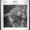
The earlier radio station is visible on oblique aerial photographs taken in 1950 (RAF 54/431, 5-7,9,13, flown 1950).

Information from RCAHMS (DE), March 1999.

References

MyCanmore Image Contributions


Contribute an Image

MyCanmore Text Contributions