
Pricing Change
New pricing for orders of material from this site will come into place shortly. Charges for supply of digital images, digitisation on demand, prints and licensing will be altered.
Achkinloch


Stone Setting (Neolithic) - (Bronze Age)
Site Name Achkinloch
Classification Stone Setting (Neolithic) - (Bronze Age)
Alternative Name(s) Achavanich
Canmore ID 8271
Site Number ND14SE 2
NGR ND 18790 41779
Datum OSGB36 - NGR
Permalink http://canmore.org.uk/site/8271


- Council Highland
- Parish Latheron
- Former Region Highland
- Former District Caithness
- Former County Caithness
ND14SE 2 1880 4178.
(ND 1880 4178) Standing Stones (NR)
OS 1:10,000 map, (1975)
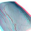
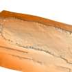
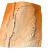
A setting of stones in the form of a truncated oval, open to the SE, which shows no sign of ever having been a completed oval. It measures 225ft long by 100ft and may originally have comprised about sixty stones of which about a third have either weathered or been removed. The stones are thick slabs of flag, standing to an average height of 5ft and set at intervals of about 8ft with their broad faces towards each aother, not along the line.
A cist measuring 5ft by 3ft 9ins, formed by four slabs set on edge stands against the most northerly stone of the setting.
This monument, which can be compared only with the example at Broubster (ND06SW 19), should probably be assigned to the earlier part of the Bronze Age.
J Anderson 1886; RCAHMS 1911; R W Feachem 1963.
An unusual setting of standing stones generally as described and planned. One or two stones along the E side outside the uprights, particularly in the NE corner suggest that there may have been a retaining kerb on this side, which is on the edge of an escarpment. The cist, roughly oriented N-S, is of the dimensions noted by the RCAHMS (1911), but is not composed of four slabs. The E side is composed of four upright slabs and one similar slab on the W side suggests that this side has been the same. There is no trace of the end stones. Elsewhere the tops of a few other stones in a similar position immediately outside the line of uprights suggests the presence of similar structures as yet uncovered.
Surveyed at 1:10,000.
Visited by OS (I S S) 20 April 1972.
A horse-shoe setting possibly comparable to the arrangement known within some stone circles, including Croft Moraig (NN74NE 12) and Broubster (ND06SW 19) as well as Stonehenge, although its opening to the SSE instead of the SW is untypical.
H A W Burl 1973.
Thirty-six flat, thin stones and snapped-off stumps. In fine weather the conspicuous Mt Morven is visible in the S over the nearby ridge and seems to be indicated by some of the stones. It may well be an astronomical foresight.
E W MacKie 1975.
No change to the previous field report.
Visited by OS (N K B) 6 December 1982.
Field Visit (30 July 1910)
At the SW. corner of Loch Stemster, about ½ m. SW of Achkinloch, is a remarkable setting of standing-stones (pl. XXX.). In form the monument is an irregular oval, broader at one end than the other, and like a horseshoe, having the setting discontinued across one end and that the narrow one. The main axis is N. and S. with the open end towards the latter direction. The total length is 226ft, the width in the middle from side to side, interior measurement, 110ft, and at the open extremity 85ft. The stones are placed with their broad faces at right angles to the direction of the setting, and are on an average from 4' to 5' in height, the highest stone-that at the SW. termination-measuring 6' 4" in height. In breadth they vary from 3' to 5', and in thickness from 8" to 20". They have been placed at distances of 8' or 9' from each other. There are a number of gaps, and presuming that the intervals were regular and that the stones from these gaps have been removed, the number of stones originally forming the monument would be fifty-four. There now remain in situ thirty-four, of which two are mere stumps, and there lie prostrate other three. Abutting against a high stone at the NE. of the monument, and on the outside, is a cist-like construction formed of four slabs set in the ground and measuring 5' X 3' 9" interiorly. There is no evidence of an interment having been found in it.
This monument was surveyed by Sir Henry Dryden in 1871,and his plan was reproduced by Dr Joseph Anderson in his work referred to below.
See Anderson, The Bronze and Stone Ages, p. 132 (plan).
RCAHMS 1911, visited 30 July 1911
OS 6” map (1907) ‘Standing Stones’
Publication Account (1995)
A remarkable setting of large stones, arranged in an unusual way as a long U-shape with one open end. Some 36 slabs or stumps survive, but some stones are missing, and there may originally have been around 54. The average size of the stones is about 1.2m to 1.5m, and the tallest is nearly 2m high. Many of the stones have been taller, but their tops have weathered and split off. The broad faces of the stones are set at right angles to the perimeter of the setting, in contrast to the practice at stone circles. Only one comparable monument is known, a ruinous U-shaped setting at Broubster, Caithness (ND 047608) [Canmore ID 7945]. The purpose of these settings is unknown, but their date is thought to be Bronze Age from their general similarity to stone circles.
Just outside the stones, close to their northeast corner and also along the east side, are some small slabs set on edge, which may be the remains of cist graves, perhaps added to the monument long after its initial purpose was forgotten. A short distance southeast of the stones, on a low hillock, are the remains of an earlier Neolithic round cairn with traces of a central chamber.
Information from ‘Exploring Scotland’s Heritage: The Highlands’, (1995).

