
Sule Skerry, Lighthouse


Lighthouse (19th Century)
Site Name Sule Skerry, Lighthouse
Classification Lighthouse (19th Century)
Canmore ID 82564
Site Number HX62SW 1
NGR HX 62153 24463
Datum OSGB36 - NGR
Permalink http://canmore.org.uk/site/82564


- Council Orkney Islands
- Parish Stromness
- Former Region Orkney Islands Area
- Former District Orkney
- Former County Orkney
HX62SW 1 62351 24246
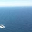
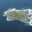
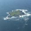
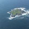
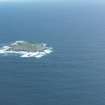
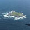
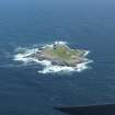
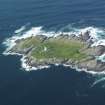
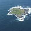
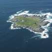
(Location cited as HY 622 244). Sule Skerry lighthouse, built 1892-4, engineer D Alan Stevenson. A tapering circular-section brick tower on a concrete base, containing keepers' rooms. There are walkways at two levels. The lighthouse is linked to the landing stage by an inclined railway.
J R Hume 1977.
Name: Sule Skerry (1892-5)
Location: N59 05 W4 24 Atlantic, 37 miles NE of Cape Wrath
Designed: D A Stevenson
Built: John Aitken
Light first exhibited: 1895
Description: Circular stone tower, painted white
Height of light above MHW: 112ft (34m)
Height of tower: 89ft (27m)
Light source and characteristics: W Gp Fl (2) ev 15 secs. Acetylene: 65,000 cp: 19nm nominal range
Fog warning apparatus: None
Manning: unwatched (automatic since December 1982), monitored from Northern Lighthouse Board HQ, Edinburgh
Most isolated British lighthouse. Listed
C Nicholson 1995.
This lighthouse is one of the four in Scottish waters over 10 miles from land, the others being Flannan (NA74NW 8.00), Dubh Artach (NM10SW 1) and Bell Rock (NO72NE 1).
Information from RCAHMS (RJCM), 1 May 2006.
Note (1 May 2006)
This lighthouse is one of the four in Scottish waters over 10 miles from land, the others being Flannan (NA74NW 8.00), Dubh Artach (NM10SW 1) and Bell Rock (NO72NE 1).
Information from RCAHMS (RJCM), 1 May 2006.

