
Pricing Change
New pricing for orders of material from this site will come into place shortly. Charges for supply of digital images, digitisation on demand, prints and licensing will be altered.
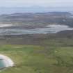
Oronsay, Iodhlann Mhor


Mound (Period Unknown)
Site Name Oronsay, Iodhlann Mhor
Classification Mound (Period Unknown)
Canmore ID 82523
Site Number NR38NE 31
NGR NR 35000 88706
Datum OSGB36 - NGR
Permalink http://canmore.org.uk/site/82523


- Council Argyll And Bute
- Parish Colonsay And Oronsay
- Former Region Strathclyde
- Former District Argyll And Bute
- Former County Argyll
NR38NE 31 3500 8869
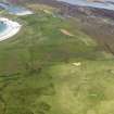
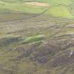
A large flat-topped oval mound, apparently natural, with a short length of the footings of a stone wall on its disturbed summit. Known locally as the 'big granary'.
visited by OS (DWR) 18 April 1974.
Field Visit (June 1977)
IODHLANN MHOR (The Big Stackyard'). This name has been applied to the flat-topped oval mound situated at NR350887, just over 200 m s of the priory. The summit area measures 27·5m from SE to NW by 22m transversely, and its sloping flanks rise to a maximum height of about 3·5 m. There are slight indications of walling in the SE sector, but limited excavation through the centre of the mound in 1929 showed that it was largely of natural origin caused by sand blowing (Pennant 1772, 272; Grieve p.378; Loder p.76, who supplies the Gaelic name; MS notes by FC Mears, August 1929, in NMRS).
RCAHMS 1984, visited June 1977

