
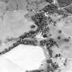
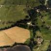
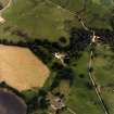
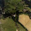
Edinample


Farmstead (Period Unassigned), Lime Kiln (Period Unassigned)
Site Name Edinample
Classification Farmstead (Period Unassigned), Lime Kiln (Period Unassigned)
Alternative Name(s) Farm And Limekiln
Canmore ID 82341
Site Number NN52SE 26
NGR NN 5998 2282
Datum OSGB36 - NGR
Permalink http://canmore.org.uk/site/82341


- Council Stirling
- Parish Balquhidder
- Former Region Central
- Former District Stirling
- Former County Perthshire
Note
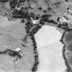
A farmstead, comprising five roofed, two unroofed buildings and one enclosure, and a limekiln is depicted on the 1st edition of the OS 6-inch map (Perthshire 1867, sheet xcii). Four roofed buildings and two enclosures are shown on the current edtion of the OS 1:10000 map (1990).
Information from RCAHMS (AKK) 14 January 1998.

