
Pricing Change
New pricing for orders of material from this site will come into place shortly. Charges for supply of digital images, digitisation on demand, prints and licensing will be altered.
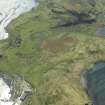
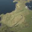
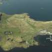
Kerrera, Ardantrive


Farmhouse (Period Unassigned), Farmstead (Period Unassigned)
Site Name Kerrera, Ardantrive
Classification Farmhouse (Period Unassigned), Farmstead (Period Unassigned)
Alternative Name(s) Ardentrive
Canmore ID 82196
Site Number NM83SW 12
NGR NM 8405 3013
NGR Description Centred NM 8405 3013
Datum OSGB36 - NGR
Permalink http://canmore.org.uk/site/82196


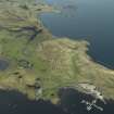
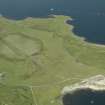
- Council Argyll And Bute
- Parish Kilmore And Kilbride
- Former Region Strathclyde
- Former District Argyll And Bute
- Former County Argyll
NM83SW 12 centred 8405 3013
See Architecture.

