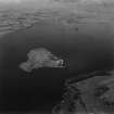
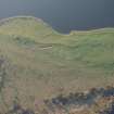
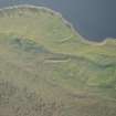
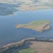
Accessibility

Font Size

100% 150% 200%

Background Colour

Default Contrast
Close Reset

St Serf's Island

Cultivation Remains (Period Unassigned)

Site Name St Serf's Island

Classification Cultivation Remains (Period Unassigned)

Alternative Name(s) Loch Leven

Canmore ID 82056

Site Number NO10SE 32

NGR NO 158 004

Datum OSGB36 - NGR

Permalink http://canmore.org.uk/site/82056

Ordnance Survey licence number AC0000807262. All rights reserved.
Canmore Disclaimer. © Bluesky International Limited 2025. Public Sector Viewing Terms

Toggle Aerial | View on large map

Digital Images

St Serf's Island and Loch Leven.  Oblique aerial photograph taken facing west.  This image has been produced from a print.
St Serf's Island and Loch Leven.  Oblique aerial photograph taken facing west.  This image has been produced from a print.Oblique aerial view of St Serf's Island centred on the Priory Church, looking S.Oblique aerial view of St Serf's Island centred on the Priory Church, looking S.Oblique aerial view of St Serf's Island centred on the Priory Church, looking SSE.General oblique aerial view of St Serf's Island in Loch Leven, looking WSW.Oblique aerial view of St Serf's Island centred on the Priory Church, looking SE.General oblique aerial view of St Serf's Island in Loch Leven, looking WSW.Oblique aerial view of St Serf's Island centred on the Priory Church, looking SSW.

Administrative Areas

  • Council Perth And Kinross
  • Parish Portmoak (Perth And Kinross)
  • Former Region Tayside
  • Former District Perth And Kinross
  • Former County Kinross-shire

References

MyCanmore Image Contributions


Contribute an Image

MyCanmore Text Contributions