
Pricing Change
New pricing for orders of material from this site will come into place shortly. Charges for supply of digital images, digitisation on demand, prints and licensing will be altered.
Upcoming Maintenance
Please be advised that this website will undergo scheduled maintenance on the following dates:
Thursday, 9 January: 11:00 AM - 3:00 PM
Thursday, 23 January: 11:00 AM - 3:00 PM
Thursday, 30 January: 11:00 AM - 3:00 PM
During these times, some functionality such as image purchasing may be temporarily unavailable. We apologise for any inconvenience this may cause.
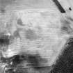
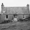
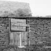
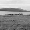
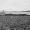
Cava, Muckle House


Farmstead (Period Unassigned)
Site Name Cava, Muckle House
Classification Farmstead (Period Unassigned)
Canmore ID 81843
Site Number ND39NW 112
NGR ND 3253 9939
Datum OSGB36 - NGR
Permalink http://canmore.org.uk/site/81843


- Council Orkney Islands
- Parish Orphir
- Former Region Orkney Islands Area
- Former District Orkney
- Former County Orkney
ND39NW 112 3253 9939
Muckle House (Mid House) comprises four structures:
Structure (a) Latest domestic unit of single room with wooden partition and chimney at each end. Rendered stone construction throughout. Tiled roof.
Structure (b) Agricultural/storage unit. No evidence of former domestic use. Wooden partitioning at west end and small sub-structure (Room II) contained at east. Drystone construction throughout. Partially surviving turf roof.
Structure (c) Earlier domestic unit (Room III) originally also including Room II before construction of cross-wall. Lean-to (Room IV) added to east with internal access through from Room III. Room I probably later agricultural/storage area to west of Room II. Internal access available from Room I to II. Drystone construction throughout.
Structure (d) Primary domestic unit? Now altered to form part of sheep dip. Extremely delapidated. Originally formed by Room II, then extended to include Room I. Drystone construction throughout.
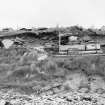
Associated features:
(e) Eight stone steps leading to shore immediately west of structure (d). Evidence of shell midden and small stonework adjacent to steps in section.
(f) Length of eroded shore section c 8m long located approx. 20m south of (e) showing large slabbed stones. These appear to underlie five parallel concrete piers (foundations?) each c 6m long and set c 0.3m apart.
(g) Low turf-covered mound c 15 x 5m immediately to east of (f) and probably associated.
(h) Angular concrete enclosure c 7 x 3.5m located approx. 100m south of (e). Concrete walling standing to height of less than 1m. Small black shed adjacent.
(i) Small concrete platform c 2 x 2m on cliff top approx. 5m east of (h).
(j) Cemented stone chimney c 1 x 1m and c 1.5m tall located approx. 115m south of (e). Some stonework in the surrounding vicinity.
(k) Low partially denuded mound c 12 x 7m immediately east of structure (a). Long axis approx E/W and maximum height c 1m. Piece of ironwork protruding. Fill seems sandy.
J R Hunter 1984

