
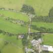
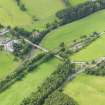
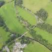
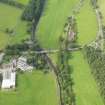
Bowland, Bowland Bridge


Road Bridge (19th Century)
Site Name Bowland, Bowland Bridge
Classification Road Bridge (19th Century)
Alternative Name(s) Gala Water; Crosslee; Caitha
Canmore ID 81824
Site Number NT44SE 24
NGR NT 45495 40123
Datum OSGB36 - NGR
Permalink http://canmore.org.uk/site/81824


- Council Scottish Borders, The
- Parish Stow
- Former Region Borders
- Former District Ettrick And Lauderdale
- Former County Midlothian
NT44SE 24 45495 40123
Bowland Bridge [NAT]
OS 1:10,560 map, 1970.
The Object Name Book of the Ordnance Survey (ONB) describes 'Bowland Bridge' as ' A stone bridge of three arches erected at the expense of the County over the Gala Water and on the old road leading from Dalkeith to Selkirk.
Name Book 1854
This bridge is situated 5km SSW of Stow village (NT44SE 19). It has four arches, and is dated 1815.
C E McWilliam 1978.
This bridge carries the B710 public road across the Gala Water immediately N of Crosslee steading (NT44SE 34).
Information from RCAHMS (RJCM), 1970.
Sbc Note (15 April 2016)
Visibility: Standing structure or monument.
Information from Scottish Borders Council

