
Houton Head Battery


Coastal Battery (Second World War), Coastal Battery (First World War)
Site Name Houton Head Battery
Classification Coastal Battery (Second World War), Coastal Battery (First World War)
Canmore ID 81798
Site Number HY30SW 40
NGR HY 3080 0360
NGR Description Centred HY 3080 0360
Datum OSGB36 - NGR
Permalink http://canmore.org.uk/site/81798


- Council Orkney Islands
- Parish Orphir
- Former Region Orkney Islands Area
- Former District Orkney
- Former County Orkney
The final decision to make Scapa Flow the main base for the Grand Fleet in the event of war (over the Invergordon dockyard in the Firth of Cromarty) was made only on the eve of war. As a consequence, in August 1914, the anchorage was undefended. It was only in mid-1915 that the anchorage was secured by guns, anti-submarine booms and blockships. In the end there were 13 batteries around the approaches to Scapa Flow
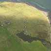
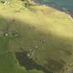
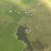
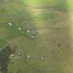
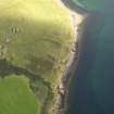
The Houton Head Battery, overlooking the Bring Deeps, was the last line of gun-defence on the NW entrance to Scapa Flow, at this point, some 3km wide. The battery covered an anti-submarine boom stretched between Houton Head and Scad Head.
The battery was armed with two 12-pdr Quick Firing guns, designed to tackle smaller, faster-moving enemy vessels.
The battery was re-armed in the Second World War.
It is not clear what of the surviving remains dates to the First World War use of the site.
Information from HS/RCAHMS World War One Audit Project (GJB) 23 September 2013.
HY30SW 40.00 centred 3080 0360
HY30SW 40.01 HY 30872 03636 Observation tower (old)
HY30SW 40.02 HY 30822 03563 and HY 30780 03625 Gun-emplacements
HY30SW 40.03 HY 30665 03580, 30746 03479 and HY 30800 03423 Searchlight Battery
HY30SW 40.04 HY 30804 03599 Magazine
HY30SW 40.05 HY 30882 03732 Engine house
HY30SW 40.06 HY 30793 03626 Observation tower (new)
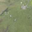
A twin 12 pounder gun emplacement situated to the SW of Houton.
J Guy 1993; NMRS MS 810/2; WO/192/269.
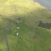
The World War Two (WW II) coast battery at Houton is situated at the end of a track from Clowally on the A964 road, which leads to a high point (59m O.D.) on Houton Head.
The battery is unusual in that a replacement observation tower was built closer to the gun-emplacements at some time during the war. The 'old' Battery Observation tower (HY30SW 40.01) has now been rebuilt and is in use as a house now annotated 'The Tower' on OS 1:10000 cale map (1977). The 'new' observation tower was located immediately behind No.1 gun emplacement.
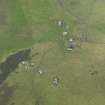
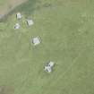
The battery consists of two brick and concrete SW-facing gun-emplacements. The emplacements are between 82 and 92m downslope from the former 'old' observation tower. Set between the two emplacements is a brick and concrete magazine.
At the bottom of the steep slope are three brick and concrete searchlight platforms and 90m to the N of the former 'old' observation tower, a large concrete and stone semi-circular roofed engine house.
The installation was armed in 1940 with two 12-pounder guns, provided with three searchlights and in 1941, designated 143 Battery manned by 534 Regiment. The last date the battery is recorded in the PRO documents is 1943 (WO 192/112, WO 192/273, WO 199/2627 and WO 199/527)
Visited by RCAHMS (DE, GS), August 1999
Field Visit (1998)
A signal station was set up on Houton Head during WWI and a boom was established between Bring Deeps and Scad Head. A coastal battery, comprising two 12 pounder guns was set up to defend the boom. During WWII the site was reused and a signal station, boom and coastal battery were established. The battery was equipped with twin 12 pounder quick-fire guns installed in concrete gun houses. The battery and ancillary buildings, which include magazines, an observation post, engine room and shelters, lie over 100m from the coast edge. Within the coastal zone there are four searchlight emplacements and the remains of small ancillary buildings. The searchlight emplacements, built of concrete, are reached by steps cutin the cliff edge. They are fully open at the front and look across Scapa Flow towards the cliffs of Hoy. They appear to be in fairly good condition.
Moore and Wilson, 1998
Orkney Coastal Zone Assessment
Project (March 2013 - September 2013)
A project to characterise the quantity and quality of the Scottish resource of known surviving remains of the First World War. Carried out in partnership between Historic Scotland and RCAHMS.

