
Aberdeenshire Canal, Dalwearie Buildings


Building(S) (Period Unassigned)
Site Name Aberdeenshire Canal, Dalwearie Buildings
Classification Building(S) (Period Unassigned)
Alternative Name(s) Aberdeen-inverurie Canal, Dalwearie Buildings
Canmore ID 81779
Site Number NJ81NW 52
NGR NJ 8102 1507
Datum OSGB36 - NGR
Permalink http://canmore.org.uk/site/81779


- Council Aberdeenshire
- Parish Kintore
- Former Region Grampian
- Former District Gordon
- Former County Aberdeenshire
NJ81NW 52 8102 1507
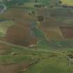
The foundations of buildings identified at this point suggests that this area may have been one of the control points of the (Aberdeen - Inverurie) canal.
Information from OS (ESC) 6 November 1961.
The remains of a rectangular building, measuring 10.8m from N to S by 5.3m transversely over grass-grown footings about 0.5m in thickness and 0.5m in height, are situated in a field of rough pasture immediately S of the Aberdeen - Inverurie Canal (NJ81NW 51).
Visited by RCAHMS (JRS), 20 November 1996.

