
Following the launch of trove.scot in February 2025 we are now planning the retiral of some of our webservices. Canmore will be switched off on 24th June 2025. Information about the closure can be found on the HES website: Retiral of HES web services | Historic Environment Scotland
Twatt Airfield


Airfield (20th Century)
Site Name Twatt Airfield
Classification Airfield (20th Century)
Alternative Name(s) Hms Tern; Isbister; Twatt Airfield Water Pipeline
Canmore ID 81752
Site Number HY22SE 58
NGR HY 2655 2283
NGR Description Centred HY 2655 2283
Datum OSGB36 - NGR
Permalink http://canmore.org.uk/site/81752


- Council Orkney Islands
- Parish Birsay And Harray
- Former Region Orkney Islands Area
- Former District Orkney
- Former County Orkney
HY22SE 58.00 centred 2655 2283
For main electricity generating station see HY22SE 89.
For possibly-associated aircraft loss, see HY22SE 93.
HY22SE 58.01 HY 26936 22606 Pillbox
HY22SE 58.02 HY 25948 22755 Cinema
HY22SE 58.03 HY 26223 22942 Control Tower
HY22SE 58.04 HY 26434 22458 Pillbox
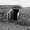
HY22SE 58.05 HY 25922 23134 Bomb Store
HY22SE 58.06 HY 25820 22883 Buildings (Officer's Mess, Squash Court)
HY22SE 58.07 HY 25609 23019 Smithy; Buildings
HY22SE 58.08 c.HY 2469 2313 Gun emplacement
HY22SE 58.09 HY 27102 02351 Gun emplacement
HY22SE 58.10 HY 26907 22945 and HY 26861 22752 Aircraft Hangars
This airfield was commissioned HMS Tern on April 1 1941 as a RNAS station. Built and guarded by the Royal Marine engineers. After the war Twatt remained a reserve station until january 1949 and was retained by the Navy until sold off in 1957.
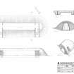
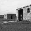
Unusually it was built with four 90ft wide runways and four dispersal areas, each with three earth-traversed 'S' hangars. Further expansion was planned in 1945 but never completed. Many buildings are left today, the most interesting being the control tower perched on top of the operations block (HY22SE 58.03). The entrance and projection room of the station cinema are still standing and the former squash court can also be seen (H22SE 58.02).
D J Smith 1983
There is a second pillbox at HY 265 225.
J Guy 1993 (Addenda).
Work began on Twatt in June 1940 and at first, its ground transport arrangements were primitive, however, by 1945 there was a fleet of 103 vehicles, many with garages, some of which survive, notably for the fire tenders located near the control tower (HY22SE 58.03). Many of the buildings and air raid shelters survive either totally, in part or as foundations and of all the Second World War Orkney airfields this survives as the most complete.
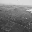
The airfield is visible on vertical air photographs, (RAF CPE/Scot/UK/185, 3463-3465, flown 9 October 1946) and RAF 541 (A) /390, 3418).
Visited by RCAHMS (DE) May 1996.
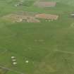
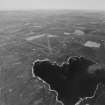
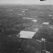
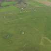
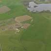
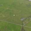
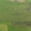
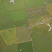
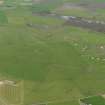
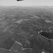
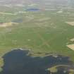
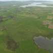
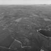
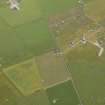
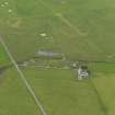
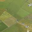
Twatt Airfield is situated on undulating ground immediately SE of the Loch of Isbister and E of the hill of Yonbell. The four grass grown runways with perimeter track are extant, though now sub-divided by modern fencing, with the control tower in the SW quadrant within the runway perimeter. The main technical area lies on the W side and there are several dispersed protected hangar bays around the perimeter of the airfield.
The four runways measure: for the 14/32 (NW-SE), 2,760ft, 04/22 (NE-SW), 2,430ft, 10/28, (E-W) 2,400ft and 01/19 (N-S), 2,370ft.
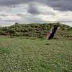
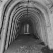
The control tower built 1941-42, is unusual in that it also built on top of the operations block. The whole structure was made ready for demolition and holes were drilled in the structure for explosives. In the event demolition was averted at the last minute, though the drilled holes can still be seen in the walls of the building.
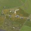
None of the aircraft hangars survive, though all are visible on RAF vertical air photographs taken in 1946 (CPE/Scot/UK/185, 3463-3465, flown 9 October 1946), but several buildings within the technical area remain. Twenty-nine hangars were supplied consisting of twelve 'S' type (Skeabrae), 16 Main or Mainhill and one Bellman.
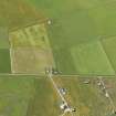
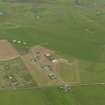
The former parachute store, sick bay and generator house are extant on each side of the track leading to the surviving working farmsteading at HY 26106 22789 and further to the west on the E side of a track leading N from the main gate are the garage repair building with surviving petrol pumps, cinema with to the N the canteen, and stand-by generator house. On the W side of the track were several hut bases and a row of air-raid shelters. There are also the concrete bases of the buildings for stores, mess hall, gun-trainer and accommodation huts. The petrol and diesel tanks for the pumps were removed during the postwar period. In addition, this area contained the telephone exchange, prison cells, Fire Station, Gas Decontamination Centre and Motor Transport shed.
Immediately E of a fence and through a gate, is the Officers squash court and beyond this the site of the Officers accommodation. Another small camp near Bryanmeadow was blown up more recently by the army.
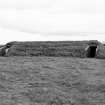
The bomb store is situated at (centred) HY 25877 3171 and consists of three earth-banked protected enclosures.
In addition, several accommodation camps were built, notably at Skogar camp and West Quoys. The camps had a capacity for 173 officers, Chief Petty Officers and ratings, 965; Wren officers 7 and Wren chief PO's and ratings 357.
In total, the airfield occupies a total of 564 acres of land, of which 440 are the original airfield of 1940, the additional 124 acres being added in 1943.
The airfield along with Skeabrae, was proposed for redevelopment during the 1950s as a NATO airbase, but this came to nothing as the base was finally built in Iceland.
The site was purchased by the Admiralty on the 10 June 1940 and the additional reqired land on 19 March 1943. An Admiralty plan dated 1940 (Dept. of Works plan no. 4692/45), shows the airfield as originally built with four groups of three hangars in the southern half and a further three proposed groups in the northern half. All of the airfield lay to the W of the main A967 road.
The expansion of 1943 led to the alteration of the layout of the hangar groups to the N, including the addition of a group to the W of the A967, additional buildings to the technical area, officer's camp and the alteration of the bomb stores plus the construction of several new accommodation camps. Workshops were provided for between two and three squadrons. It is not clear from the 1940 plan whether the two pillboxes (HY22SE 58.01 and HY22SE 58.04 ) were contemporary to the orginal plan or were additions in 1943.
Within the airfield perimeter are three abandoned farmsteads.
Visited by RCAHMS, (DE, GS,SW), August 2000
Watching Brief (5 March 2012 - 16 March 2012)
A watching brief was undertaken by Orkney Research Centre for Archaeology (ORCA), on the excavation of two stretches of water pipeline trench near Twatt Airfield, Sandwick, Orkney.
The excavation of a 250m stretch of pipeline, running to the south of the Linklater Road (centered on HY 2659 2165) and a 890m stretch of pipeline, running to the north of the Bryameadow Road (centered on HY 2645 2244) were monitored under constant archaeological supervision.
No significant archaeological finds or features were recorded.
From: ORCA 334 Twatt Airfield Watching Brief DSR March 2012

