
Following the launch of trove.scot in February 2025 we are now planning the retiral of some of our webservices. Canmore will be switched off on 24th June 2025. Information about the closure can be found on the HES website: Retiral of HES web services | Historic Environment Scotland
Raf Netherbutton, Chain Home Radar Station


Air Raid Shelter(S) (Second World War), Anti Aircraft Defences(S) (20th Century), Military Camp(S) (20th Century), Radar Station (20th Century)
Site Name Raf Netherbutton, Chain Home Radar Station
Classification Air Raid Shelter(S) (Second World War), Anti Aircraft Defences(S) (20th Century), Military Camp(S) (20th Century), Radar Station (20th Century)
Alternative Name(s) Z Batteries
Canmore ID 81727
Site Number HY40SE 32
NGR HY 46211 04396
NGR Description Centred HY 46211 04396
Datum OSGB36 - NGR
Permalink http://canmore.org.uk/site/81727


- Council Orkney Islands
- Parish Holm
- Former Region Orkney Islands Area
- Former District Orkney
- Former County Orkney
HY40SE 32 centred 46211 04396
For farmstead (HY 4593 0443) within the the defined area of this radar station, see HY40SE 60.
Information from RCAHMS (RJCM), 12 February 2001.
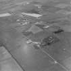
A Chain Home radar station, the transmitter block at HY 4621 0440.
Information from Mr I Brown, October 1998.
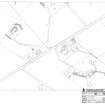
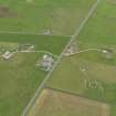
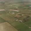
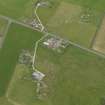
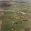
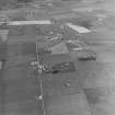
The remains of Netherbutton Radar Station are situated on both sides of the A 961 at a farmsteading annotated 'Roadside cottage' on the OS digital 1:2500 scale map.
The surviving remains consist of the following:
on the E side of the road four mast bases at HY 46340 04701, HY 46388 04761, HY 46427 04695 and HY 46379 04635 which surround a house annotated 'The Ranch' built on the site of the Receiver (Rx) block.
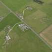
On the W side of the road the mast bases have been removed, but the transmitter block (Tx) is relatively intact apart from the construction of a house on the upper level. The former gate/guard house (HY 46219 04538) survives at the main gate along with the original perimeter fence which would appear to extend around much of the station. At HY 46126 04557 are the remains and footings of several buildings and the blast walls of the stand-by set house are at HY 46322 04458.
Disturbed ground to the S of Netherbutton farmsteading revealed at least two concrete structures amongst what is now heavily overgrown area.
Netherbutton Radar Station is visible on WW II RAF vertical air photographs (WL/10, 1.35-1.37, flown 4 July 1942). The images show the two sets of masts, Rx and TX blocks plus several groups of huts. The remains of buildings noted at HY 46126 04557 can be seen as eight huts, one of which is a large 'E' shaped block.
The Radar installation was provided with anti-aircraft protection in 1942 by four groups of fixed rocket projectile 'Z' batteries centred at HY 45981 04325, HY 46310 04373, HY 46241 04667 and HY 46471 04785. These rocket launchers may account for the disturbed ground with two concrete structures S of Netherbutton (HY 45981 04325), which is noted above. Addionally a light anti-aircraft battery was also provided.
The house annotated 'Darmont' (OS digital 1:2500 scale map) is visible on the wartime images, located within the station perimeter fence was used as officers quarters during WW II.
Part of the site was re-used in the postwar period as the OS 1:10000 scale map (1970) is annotated as a 'television station' and depicts three masts to the S and SW of the orginal Rx block.
Visted by RCAHMS (DE, GS) August 1999
Note (20 June 2022)
The Pillbox Study Group report two Stanton type air raid shelters within the radar station complex at HY 4640 0461 and HY 4612 0451 depicted on the OS 1:2500 map (1966). The Air Raid Shelter at HY 4612 0451 within the military camp is still extant and is visible on latest 25cm vertical aerial photography.
Information from Pillbox Study Group to HES 20 June 2022

