
Pricing Change
New pricing for orders of material from this site will come into place shortly. Charges for supply of digital images, digitisation on demand, prints and licensing will be altered.
Islay, Grasdale


Farmstead (Period Unassigned), Rig And Furrow (Medieval) - (Post Medieval)
Site Name Islay, Grasdale
Classification Farmstead (Period Unassigned), Rig And Furrow (Medieval) - (Post Medieval)
Canmore ID 81678
Site Number NR24NE 7
NGR NR 2999 4756
NGR Description Centred on NR 2999 4756
Datum OSGB36 - NGR
Permalink http://canmore.org.uk/site/81678


- Council Argyll And Bute
- Parish Kildalton And Oa
- Former Region Strathclyde
- Former District Argyll And Bute
- Former County Argyll
NR24NE 7 2999 4756 (Centred)
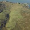
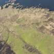
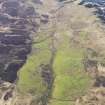
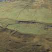
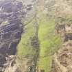
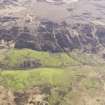
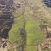
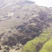
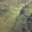
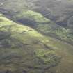
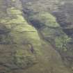
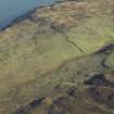
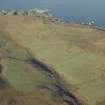
(NR 2999 4757) A probable 18th/19th century deserted farmstead situated on level shelf on gentle SW-facing hillslope. It comprises two rectangular buildings surviving to roof height; the largest is 26m by 6m. There are several field walls visible and evidence of extensive rig and furrow cultivation in the vicinity.
Visited by OS (TRG) 29 May 1978
A farmstead comprising one unroofed long building of four compartments, one partially roofed building and two enclosures is depicted on the OS 1st edition 6-inch map (Argyllshire 1882, sheet ccxxxi). Two unroofed buildings and two enclosures are shown on the current edition of the OS 1:10000 map (1981).
Information from RCAHMS (SAH) 4 December 1998

