
Pricing Change
New pricing for orders of material from this site will come into place shortly. Charges for supply of digital images, digitisation on demand, prints and licensing will be altered.
Burghead Bay, Roseisle Forest


Anti Tank Blocks (20th Century), Military Installation(S) (20th Century)
Site Name Burghead Bay, Roseisle Forest
Classification Anti Tank Blocks (20th Century), Military Installation(S) (20th Century)
Alternative Name(s) Burghead Bay Anti-invasion Beach Defences
Canmore ID 81613
Site Number NJ16NW 70
NGR NJ 1100 6685
NGR Description NJ 1044 6500 to NJ 1133 6854
Datum OSGB36 - NGR
Permalink http://canmore.org.uk/site/81613


- Council Moray
- Parish Duffus
- Former Region Grampian
- Former District Moray
- Former County Morayshire
NJ16NW 70.00 1044 6500 to 1133 6854
NJ16NW 70.01 NJ 10182 65613 Pillbox
NJ16NW 70.02 NJ 10890 66520 Pillbox
NJ16NW 70.03 NJ 11154 67354 Pillbox
NJ16NW 70.04 NJ 11335 68597 Pillbox
For other Burghead Bay defences see also NJ06SW 63.00, NJ06NE 2.00 and NJ06SE 68.00.
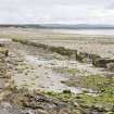
A series of pillboxes and anti-tank blocks run around the bay. At NJ 1038 6584, there is a pillbox sliding down the dunes.
Visited by Mr J Guy, 3 December 1992.
NMRS, MS/712/10; MS 810/1, 11-112, (Vol.2)
A double line of WW II anti-tank blocks runs along the coast (from NJ 1044 6500 to NJ 1133 6854) above the Mean High Water springs and immediately in front of the dune system. The line of defences continues W to Findhorn.
Within the line of blocks are four pillboxes (NJ16NW 70.01 - NJ16NW 70.04). The pillboxes and anti-tank blocks are visible on wartime oblique air photographs (RAF 241F, B2- B8, flown 26 February 1941). The pillbox noted by Mr Guy at NJ 1038 6584 probably equates to that at NJ 10182 65613.
This section forms the left sector (Burghead to Findhorn) part of the anti-invasion beach defences of Moray which ran from Cullen Bay to Burghead Bay. The defences include pillboxes, infantry observation posts, artillery observation posts, Home Guard observation posts, Home Guard Defended localities, keeps, wire obstacles, aircraft immobilisation poles, tubular scaffolding and two sections of airfield perimeter defences which included the light and heavy anti-aircaft batteries possibly providing a secondary beach defence role. (Lossiemouth and Kinloss).
Information from RCAHMD (DE), August 2003.
Publication Account (2009)
The website text produced for Roseisle webpages on the Forest Heritage Scotland website (www.forestheritagescotland.com).
Introduction: A World War II coastline
Discover the remains of World War II defences along the Moray coast, in Roseisle Forest.
In the summer of 1940, the threat of German invasion was very real. The British defence plan outlined a need to protect areas of the coast where the enemy could land.
One such area was Moray. This led to the construction of a series of defence structures that ran between Cullen Bay and Burghead Bay, through today's Roseisle and Lossie Forests..
Along the beach at Burghead Bay, where Roseisle Forest now stands, a line of concrete anti-tank blocks and pillboxes were constructed.
Due to coastal erosion and the movement of the sand, some of these defences have been lost or moved. For example, a few pillboxes have tipped over due to the movement of the sand. Discover more about their construction and use in our "Evidence" story.
Nearby Lossie Forest offers a more complete representation of what the defences would have looked like during World War II. Even there, however, it is difficult to picture what it was like.
Aerial photographs, taken by the Royal Air Force in 1941, show a dramatically different looking landscape. Various observation posts ran along the coastline, some to keep watch on the beaches and others to keep watch for aircraft.
The barbed wire that lined the beaches is now long gone. Lengths of man-made earth banks and dug-out ditches created more obstacles for the Germans to cross. Today these are difficult to detect, as ditches were filled back in with earth and the banks levelled.
Examining the evidence: pillboxes
Several World War II pillboxes survive on the beach at Roseisle Forest. These small gun stations formed an important part of the coastal and inland defences and protected important military targets such as airfields.
Pillboxes are small concrete structures. Soldiers could stand inside the structures and open fire on the enemy at close range. During 1940, over 18,000 were constructed all over Britain.
In June 1940, branch FW3 of the War Office Directorate of Fortifications and Works issued twelve "Standard Design Drawings" for building pillboxes. In practice, designs were often adapted to suit local tactical needs and availability of materials. The Roseisle pillboxes are Type 24, an irregular hexagonal shape.
Despite variations in design, all pillboxes are flat-roofed buildings, no more than 2m in height. A small concrete wall often protected the back entrance of the pillbox.
Small rectangular windows are called firing loops. The size and shape of these openings allowed the guns inside to cover the area between this pillbox and the next. At the same time, they limited how much enemy gun fire could get in, protecting the soldiers.
Some pillboxes were cleverly camouflaged as buildings; others, like Roseisle, were painted and covered in netting.
It is thought that the concrete walls could not have withheld enemy fire for long. However, they would slow down an enemy invasion. During battle, this could have proven vital in allowing the Home Forces time to organise a counter-attack.

