
Milltown Airfield


Airfield (20th Century), Radio Station (20th Century)
Site Name Milltown Airfield
Classification Airfield (20th Century), Radio Station (20th Century)
Alternative Name(s) Millton Airfield; Raf Milltown; 81 Signals Unit; Stonewalls
Canmore ID 81609
Site Number NJ26NE 15
NGR NJ 265 655
Datum OSGB36 - NGR
Permalink http://canmore.org.uk/site/81609


- Council Moray
- Parish Urquhart
- Former Region Grampian
- Former District Moray
- Former County Morayshire
NJ26NE 15.00 265 655
NJ26NE 15.01 NJ 26409 65139 Aircraft Hangar
NJ26NE 15.02 NJ 26185 65019 Buildings
NJ26NE 15.03 NJ 2747 6607 Bomb Store
NJ26NE 15.04 NJ 26536 65194 Control Tower
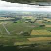
Begun as a Q-site (decoy) for nearby Lossiemouth (NJ26NW 50), the decoy was abandoned during October 1941 and construction of three runways undertaken, opening during 1943. The airfield finally closed during 1977 to become a radio transmitter site.
D J Smith 1983.
Used by RAF as radio transmitter site.
Visited by J Guy, 2 December 1992.
NMRS, MS/712/8.
Air photograph: AAS/97/12/G27/15.
NMRS, MS/712/29.
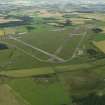
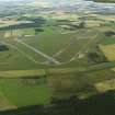
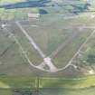
Milltown Airfield is situated to the E of the River Lossie and W of Innes House.
Almost all the buildings have been cleared apart from one T2 type aircraft hangar (NJ26NE 15.01) and one or two of the ancilliary buildings near the S gate.
The site is still a Ministry of Defence Radio Station used by 81 Signals Unit and a large number of masts now occupy the runways.
The airfield is visible on vertical air photographs (106G/Scot/UK 169, 3304-3307 and 5326-5328, flown 26 August 1946).
Standing Building Recording (October 2021)
NJ 2659 6579 A historic building recording was carried out at Milltown Airfield, in October 2021, in advance of the proposed development on the site of a solar powered electricity generating station. The site is a disused Military Airfield located between Lhanbryde and Lossiemouth. Milltown Airfield is a military airfield dating to the Second World War.
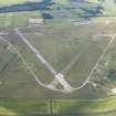
A basic (level 1) historic building survey (ALGAO: Scotland 2013) was undertaken of the airfield. This included a photographic record of the runways and the condition of their surfaces; of the post-airfield structures such as radar mast bases; recording of views towards the Listed Buildings adjacent to the runway; and recording of several smaller structures within the site.
The runways and perimeter roads of the military airfield were constructed from concrete, generally in 4 x 4m panels. In places this had worn, exposing the internal structure. Several areas of hardstanding adjacent to the runways were recorded, these contained markings for landing planes. A later tarmac surface had been laid across some areas of the airfield; this had also decayed in places. The airfield was closed in 1977 and became a radio transmitter site. There are several groups of concrete structures marking the locations of the mast bases. Many of these areas were fenced off and contained small shrubs, which in some places completely masked the concrete structures.
In the southwestern part of the airfield was an unusual structure
constructed of soil filled ammunition boxes. This had largely collapsed on one side, but contained two cells, windows and had a corrugated iron roof. A pillbox of Yarnold-Sangar type was recorded on the W side. At the S side of the airfield was a small concrete installation of unknown function. A further circular brick structure, likely to be the base of a Second World war pillbox of Norcon type and a small square building were also recorded at the S side, although these were both immediately outwith the boundary of the site.
Information from E. Jones – Addyman Archaeology, 2021.
(Source: DES Vol 22)
OASIS ID: addymana1-432451

