
Innes Links, Anti-invasion Beach Defences


Military Installation (20th Century)
Site Name Innes Links, Anti-invasion Beach Defences
Classification Military Installation (20th Century)
Alternative Name(s) Spey Bay Anti-invasion Beach Defences
Canmore ID 81608
Site Number NJ26NE 14
NGR NJ 2815 6785
NGR Description NJ 2560 6815 to NJ 2999 6715
Datum OSGB36 - NGR
Permalink http://canmore.org.uk/site/81608


- Council Moray
- Parish Urquhart
- Former Region Grampian
- Former District Moray
- Former County Morayshire
NJ26NE 14.00 2560 6815 to 2999 6715
For information on Emergency Coast Battery (transferred to site number NJ26NE 30.00) and for W section of coast defences, see NJ36NW 5.00.
NJ26NE 14.01 NJ 29697 67175 Pillbox; Anti-Tank Blocks
NJ26NE 14.02 NJ 29372 67371 Pillbox
NJ26NE 14.03 NJ 29029 67521 Pillbox
NJ26NE 14.04 NJ 28722 67709 Pillbox
NJ26NE 14.05 NJ 28407 67805 Pillbox
NJ26NE 14.06 NJ 28059 67982 Pillbox
NJ26NE 14.07 NJ 27725 68117 Pillbox; Anti-Tank Blocks
NJ26NE 14.08 NJ 27425 68262 Pillbox
NJ26NE 14.09 NJ 26644 68373 Pillbox
NJ26NE 14.10 NJ 26337 68494 Pillbox
NJ26NE 14.11 NJ 26203 68601 Pillbox; Anti-Tank Blocks
NJ26NE 14.12 NJ 25897 68439 Pillbox
NJ26NE 14.13 NJ 25579 68144 Pillbox; Anti-Tank Blocks
NJ26NE 14.14 NJ 28239 67848 Pillbox (possible)
NJ26NE 14.15 NJ 26695 68412 Pillbox
NJ26NE 14.16 NJ 26202 68578 Pillbox
NJ26NE 14.17 NJ c. 2576 6836 Pillbox (possible)
There are a 'coast battery' (GRC NJ26NE 15) and a pillbox (GRC NJ26NE 17) at NJ 2815 6785 and NJ 2841 6781, respectively.
NMRS MS/712/9.
GRC NJ26NE 15 2815 6785. Coastal battery comprising 2 x 6 in. gun emplacements, 3 x engine rooms and 2 x searchlight emplacements set facing N across foreshore (NJ24NE 30.00). The battery formed at Lossiemouth on 28 May 1941; it had been reduced to care and maintenance by April 1945 and removed by June 1945.
Defence line of anti-tank blocks and pillboxes protecting the dunes.
Visited by J Guy
This battery and defence line is visible on Royal Air Force vertical aerial photographs taken in 1945 (106G/UK 750: 5008, 5009) and oblique aerial photographs taken in 1950 (541/A/487: 0077-0078).
Information from RCAHMS (KM) 13 March 2001.
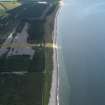
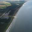
This section forms the east sector (Kingston to Lossiemouth) part of the anti-invasion beach defences of Moray which ran from Cullen Bay to Burghead Bay. The defences include pillboxes, infantry observation posts, artillery observation posts, Home Guard observation posts, Home Guard Defended localities, keeps, wire obstacles, aircraft immobilisation poles, tubular scaffolding and two sections of airfield perimeter defences which included the light and heavy anti-aircaft batteries possibly providing a secondary beach defence role. (Lossiemouth and Kinloss).
Information from RCAHMS (DE), September 2003
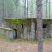
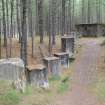
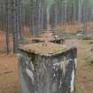
A visit to the anti-invasion defences in February 2008 noted that the line of blocks remained almost complete along with the assocated pillboxes, blockhouses and emergency coast battery (NJ26NE 30.00). Nearly all of the line of blocks have been constructed using the shuttered concrete technique and most retain the metal lifting loops. The pillboxes are nearly all type 24 with alternate small rectangular' blockhouses' the whole length of the beach. Only one pillbox would appear to have suffered from under-cutting by the sea, that at NJ 28406 67905 (NJ26NE 14.05), the structure now leans to one side. The erosion has ocurred since 1992 when Mr J Guy visited the site.
In addition, several of the anti-landing trenches or ditches were noted running across the links behind the beach. They survive as a series of elongated pits many filled with water or beach pebbles running at right angles to the line of anti-tanks blocks.
These ditches and trenches are visible on RAF WW II vertical air photographs (241cE1-E2and B1 to B10, flown 13 March 1941).
Visited by RCAHMS (DE, NG), 27 February 2008
Publication Account (2009)
The website text produced for Lossie World War II defences webpages on the Forest Heritage Scotland website (www.forestheritagescotland.com).
Introduction: Defending the coast
During World War II, the construction of a line of defences along the Moray coastline aimed to slow down a possible German invasion. Today, in Lossie Forest, you can explore the remains of these defences.
In 1940, Britain was under threat of German invasion]. As a result, a plan was put into action to defend any coastline where the enemy could easily land.
The Moray coastal defences ran between Cullen Bay and Findhorn Bay, through today's Lossie and Roseisle Forests].
Within Lossie Forest, you will discover evidence of the variety of defences constructed. Firstly, there are the concrete foundations of a military camp. This is where the soldiers who constructed and manned the defences lived.
Concrete anti-tank blocks ran the full length of the defences. They are no longer complete but long sections of the line are still visible on the edge of the forest.
Pillboxes were another part of the defences. Two alternating designs, square and hexagonal shaped, zigzagged a line along the coastline. Over twenty of these still remain at Lossie.
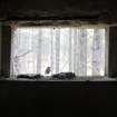
On the edge of the forest, you will discover the ruins of a Coastal Battery, consisting of a number of structures. The long range guns stationed at the battery protected Lossiemouth port from attack by sea.
Discover how the coastal battery operated in our "People" story.
People Story: Running a coastal battery
Now derelict, the coastal battery at Lossie Forest defended Lossiemouth harbour from German attack during World War II.
In June 1940, a Polish Army Engineer Corps constructed some of these defences. Wieslaw Szczygiel, a Polish soldier in that unit, recalls briefly working on them before moving to a unit at Tentsmuir.
The 227th battery of the 501 Coastal Regiment manned the coastal station once it was completed on the 28th of May 1941.
At the front of the battery were two gun emplacements, armed with large 6 inch Mark 11 guns. These were old World War I guns removed from naval ships and stored until needed. They were powerful and could fire long distances, excellent for keeping enemy ships at bay.
Behind the gun emplacements, there were a series of other buildings. Two machine gun emplacements would provide firepower to defend the beach if enemy troops landed.
A vital building was the Battery Observation Post (BOP). As command control, this was where the calculations for aiming and firing the big guns were made. Later, radar was introduced to help detect the enemy's approach.
Two searchlight stations provided light to see an enemy attack at night.
To prevent detection from enemy planes the buildings were painted and hidden with web netting. Today this camouflage is no longer evident.
In April 1945, the battery went out of operation followed by the removal of the guns two months later.
Evidence Story: Using laser technology to interpret the past
In 2009, AOC Archaeology undertook a survey of the World War II remains in Lossie Forest. This record will help Forestry Commission Scotland manage the site. It also provides new opportunities for presenting the site to the public.
A key element of this survey was the recording of the western gun emplacement of the coastal battery, located on the beach.
AOC Archaeology used a laser scanner to record the structure and create a detailed 3-dimensional digital reconstruction of the building. You can view the results as an animation - the powerful laser scanner has even picked up the modern graffiti.
This technique is a relatively new way of recording archaeological remains and historic buildings. The laser scanner shoots laser rays at different points inside and outside the building. It records the distance from the scanner to each point. This information is collected as digital data points, called point-clouds.
Using the point-clouds, the building's shape is accurately recreated, as you can see in our animation. This information also created 2-dimensional plans and elevations of the building, similar to architectural plans.
This digital information forms the basis for a series of reconstruction paintings of how the gun emplacement looked in World War II. The artist, Drew Smith, selected his view point and accurately scaled his drawings.
Flick through the images and see the artistic process of converting the digital information into a final, watercolour reconstruction of the gun emplacements.

