
Pricing Change
New pricing for orders of material from this site will come into place shortly. Charges for supply of digital images, digitisation on demand, prints and licensing will be altered.
Upcoming Maintenance
Please be advised that this website will undergo scheduled maintenance on the following dates:
Thursday, 9 January: 11:00 AM - 3:00 PM
Thursday, 23 January: 11:00 AM - 3:00 PM
Thursday, 30 January: 11:00 AM - 3:00 PM
During these times, some functionality such as image purchasing may be temporarily unavailable. We apologise for any inconvenience this may cause.
Cove Quarries


Sandstone Quarry(S) (18th Century) - (20th Century), Tramway(S) (19th Century) - (20th Century)
Site Name Cove Quarries
Classification Sandstone Quarry(S) (18th Century) - (20th Century), Tramway(S) (19th Century) - (20th Century)
Alternative Name(s) Cove Wood; Kirtle Water; Brownknowe
Canmore ID 81441
Site Number NY27SE 36
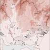
NGR NY 2542 7105
NGR Description From NY 253 710 to NY 260 707
Datum OSGB36 - NGR
Permalink http://canmore.org.uk/site/81441

- Council Dumfries And Galloway
- Parish Kirkpatrick-fleming
- Former Region Dumfries And Galloway
- Former District Annandale And Eskdale
- Former County Dumfries-shire
Field Visit (2 December 1994)
NY27SE 36 253 710 to 260 707
The Statistical Account of 1794 mentions Cove Quarry and the fine sandstone that was being worked there; it was used locally for paving, stairs and tombstones, but much was exported in dressed form. By the 1850's, the quarry was connected by a siding to the Caledonian Railway, and this served quarrying operations on both sides of the Kirtle Water; the tramway lines and turntable that served the quarry are shown on the 1st edition of the OS 6-inch map (Dumfriesshire, sheet lviii, 1862).
Although the quarry was closed for a number of years and only reopened in 1895, the workings were considerably extended on the S side of the Kirtle Water between 1862 and 1900. A mineral railway is annotated on the 2nd edition of the map (Dumfriesshire, sheet lviii, 1900) running S from the main line, through a large roofed building, and across the Kirtle Water. The crossing point is the same on both editions of the map and, although the structure which spanned the river has long since disappeared, the embankments can still be seen to either side.
Nothing survives of the quarry buildings that are depicted on the 2nd edition, although one later building remains on the S side towards the NW extent of the quarry. In addition to the rail lines shown on the S side on the 2nd edition, several more railway cuttings can be seen, and most of these terminate at a revetted loading platform. The workings are now largely waterfilled, and a plantation extends across much of the site.
Visited by RCAHMS (ARW, SPH), 2 December 1994.
OSA 1791-9.
Listed as quarry.
RCAHMS 1997.

