|
Prints and Drawings |
DC 32183 |
Records of the Royal Commission on the Ancient and Historical Monuments of Scotland (RCAHMS), Edinbu |
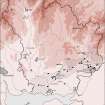
Map showing the principal locations in Annandale and Eskdale exploited for sandstone, limestone and coal during the 18th and 19th centuries. Published in Eastern Dumfriesshire: an archaeological landscape. |
1996 |
Item Level |
|
|
Digital Files (Non-image) |
GV 007471 |
Records of the Royal Commission on the Ancient and Historical Monuments of Scotland (RCAHMS), Edinbu |
Map showing the principal locations in Annandale and Eskdale exploited for sandstone, limestone and coal during the 18th and 19th centuries. Published in Eastern Dumfriesshire: an archaeological landscape. |
1996 |
Item Level |
|
 |
On-line Digital Images |
SC 1917805 |
Records of the Royal Commission on the Ancient and Historical Monuments of Scotland (RCAHMS), Edinbu |
Map showing the principal locations in Annandale and Eskdale exploited for sandstone, limestone and coal during the 18th and 19th centuries. Published in Eastern Dumfriesshire: an archaeological landscape. |
1996 |
Item Level |
|


