
Pricing Change
New pricing for orders of material from this site will come into place shortly. Charges for supply of digital images, digitisation on demand, prints and licensing will be altered.
Stronetoper


Township (Period Unassigned)
Site Name Stronetoper
Classification Township (Period Unassigned)
Alternative Name(s) Stronalia
Canmore ID 81415
Site Number NN89NW 2
NGR NN 849 965
Datum OSGB36 - NGR
Permalink http://canmore.org.uk/site/81415


- Council Highland
- Parish Kingussie And Insh
- Former Region Highland
- Former District Badenoch And Strathspey
- Former County Inverness-shire
NN89NW 2 849 965
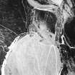
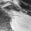
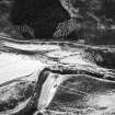
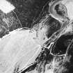
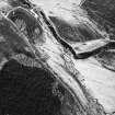
Seven roofless buildings in two groups, situated on the W side of the River Feshie, are depicted on the current 1:10,000 OS map (c.1971).
Information from RCAHMS (PM) 5 January 1995.
What may be a single unroofed shieling-hut is depicted on the 1st edition of the OS 6-inch map (Inverness-shire 1872, sheet ciii). Seven unroofed buildings are shown on the current edition of the OS 1:10000 map (1971).
Information from RCAHMS (AKK) 22 July 1996.
Two buildings and part of the head-dyke of Stronalia township were noted by J Wordsworth during a pre-afforestation survey (NMRS MS 961/2). The buildings, situated at NN 8490 9625, measure 12m by 5m and 10m by 5m externally with 0.8m thick walls.
J Wordsworth 1996; NMRS MS 961/2
NN 8490 9625 Stronalia. Two well-preserved longhouses 12 x 5m and 10 x 5m with walls 0.8m thick. Not shown on earlier OS maps.
NN 8495 9670 Stronalia. Low stone dyke, c 100m long surviving.
Sponsor: Wills Woodland Trust.
J Wordsworth 1997
Sites identified during an archaeological survey of Glen Feshie. A total of 27 settlements (or clusters of buildings) were recorded, with a total of 293 individual archaeological features.
The settlement is comprised of two groups of buildings situated on a river terrace, on the west bank of the River Feshie.
Northern group - 5 structures.
Southern group - 5 structures.
M. Marshall, October 2003.

