
Ballachly, 'monastery'


Building (Norse), Burial Ground (Medieval), Chapel (Medieval), Monastery (Medieval)(Possible), Monastic Settlement (Medieval)(Possible)
Site Name Ballachly, 'monastery'
Classification Building (Norse), Burial Ground (Medieval), Chapel (Medieval), Monastery (Medieval)(Possible), Monastic Settlement (Medieval)(Possible)
Alternative Name(s) Chapel Hill, Dunbeath
Canmore ID 8134
Site Number ND13SE 18
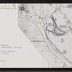
NGR ND 1567 3035
Datum OSGB36 - NGR
Permalink http://canmore.org.uk/site/8134


- Council Highland
- Parish Latheron
- Former Region Highland
- Former District Caithness
- Former County Caithness
ND13SE 18 1567 3035
(ND 1563 3039) Site of (NAT) Chapel & Grave Yard (NR)
OS 6" map, Caithness, 1st ed., (1871)
The chapel, according to local tradition, survived until the Reformation, and the graveyard, in part, until the 18th century when most of it was carried away by a flooding of the Burn of Houstry, during which coffins were seen to be swept down to the sea. The little that survived the flood was eradicated by cultivation. The priest's house is said to have stood on the rising ground above the junction of the Burn of Houstry with the Dunbeath Water.
Name Book 1871.
(ND 1570 3033) Chapel and Graveyard (NR) (Site of)
OS 6" map, Caithness, 2nd ed., (1907)
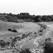
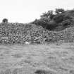
At Ballachly is the site of a chapel. From the haugh land near the river there rises a ridge some 80 to 100 yds in length, and at right angles to it there runs towards the river a wall 5ft thick and still some 8 to 10ft high. Along the level to the base of the ridge at the E are the ruins of a similar massive wall. Bishop Forbes (Craven 1886) records that he was told on his visit to Caithness in 1762 that here 'had been a small monastery called of old the Chapel or Church of Peace'.
J B Craven 1886; RCAHMS 1911.
All that remains of this site are the massive walls on the S, E and W sides of a secluded haugh at ND 1567 3037. They are of drystone construction incorporating large facing blocks, roughly coursed, with a rubble core. The S wall, which survives to a height of 3m, is 1.9m thick at base, tapering to 0.6m at the top; the other walls remain to a maximum height of 0.8m. The manner in which they surround the haugh suggests an early date, and their most likely origin appears to be as the precinct wall of an early monastery. The "priest's house" may be the building at ND 1570 3033 of which only the footings remain.
Visited by OS (N K B) 25 March 1968.
This seems to be an Early Christian monastery whose church continued in use until later medieval times. It may have been associated with St Triduana since there was, apparently, a 'Croit Trolla' nearby (Beaton 1909).
D Beaton 1909; A D S MacDonald and L R Laing 1969.
(ND 1567 3035) Monastery (NR) (remains of)
OS 1:10,000 map, (1979)
The massive walls of the supposed monastery are as described by the previous OS field surveyor and as depicted on the OS map.
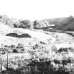
Wall 'A' contains a blocked gap widening towards the wall-head. 'B', though reduced to a maximum height of 0.8m, is the same width and displays the same boulder base footings as 'A', and the amount of tumble around it suggests that it could have been the same height. It is possible that these two walls, together with natural knoll 'E', were originally joined to enclose the haugh; a wall along the W side could have been destroyed by flash-flooding of the Dunbeath Water and the Houstry Burn, and that along the N side by the development of a hollow-way. There is no no trace of such walls and no evidence of structures within the postulated enclosure, now under permanent pasture. On the level summit of knoll 'E', the building footings suggested by OS field surveyor (N K B), to be the remains of a "priese's house" are indistinguishable from the ruins of a typical croft, and the associated walls are narrow and of different character to walls A and B. However, the position is unusual for a croft, there being no easy access up the very steep slopes of the knoll. To the E and SE of the alleged monastery is further walling ('C' and 'D') which may be contemporary. 'C' is 0.8m in maximum height and the width is 1.8m at the massive base-footings. Wall 'D' is less strong and, connecting two low cliffs, effectively encloses, with the river, an area of secluded haughland S of the supposed monastery.
The evidence for a monastery at this site is very slender, based apparently on two factors: (i) the tradition of a pre-Reformation chapel and graveyard, and (ii) the survival of what has been considered to be a precinct wall. The latter, exemplified by wall 'A', resembles a precinct wall of a formal early medieval monastery in terms of height only; a wall of dry stone construction, battered and 3.0 m high is unknown at other monastic establishments in northern Scotland, and it would be remarkable that a wall of such height could survive from the Early Christian era. The site has poor defensive capability, and the secluded nature of the assumed enclosed area is more akin to a monastic settlement than a fortification. It is possible that the walls were built merely at the whim of a local eccentric for no important purpose, and this may explain their uniqueness.
Visited by OS (N K B) 15 December 1982.
It is possible that this could be the site of the 'hospital' at which the English envoys were accommodated on the night of 3rd October 1290, on their way north to attend the reception of the Maid of Norway (see ND13SE 54).
B E Crawford 1982.
Unspecified Geophysical Survey Technique (1998)
ND 1570 3032 A non-invasive investigation of this possible Early Christian monastic site was undertaken in order to inform management policy for the site and to increase the level of information available. Topographic and geophysical surveys were carried out on the site and the surrounding areas, the geophysical survey being limited to areas outside the Scheduled area. The topographic survey revealed that the summit of the hill was divided into two areas, one with a single circular structure and the other with a two-chambered rectilinear building and a series of roughly circular small structures now reduced to rubble. The geophysical survey revealed a number of interesting anomalies, the most important of which is consistent with a large ditch. This would have restricted access to the site and, if proved to be a ditch, could have been the vallum for a monastery.
Sponsors: Historic Scotland, Dunbeath Preservation Trust, Mr and Mrs Bethune.
I Banks and J Hooper 1998.
Earth Resistance Survey (July 2007)
ND 1567 3035 A geophysical survey was carried out by a team from Nottingham University on the site of the supposed Early Christian monastic complex at Chapel Hill, Ballachly, near Dunbeath, in July 2007. Previous geophysical work had been carried out on the site by GUARD in 1998 and 2002 using resistivity (GUARD Project 1002). The present survey went over some of the ground covered by GUARD, where there was some ambiguity, using resistivity, and additionally carried out a gradiometer survey. In the light of the geophysical survey, limited
site assessment by trial trenching was conducted outside the scheduled area, to further the understanding of the geophysical plots.
Archive to be deposited with the Edinburgh SMR.
Funder: University of Nottingham.
Excavation (July 2007)
ND 1567 3035 A terrace to the SE of the scheduled area appeared to be defined by anomalies suggestive of an enclosure ditch. However, excavation (Trench 1) indicated that the anomalies had been caused by freshwater springs following the contour of the terrace. At the top of the slope there was some evidence for a substantial dry stone wall (approximately 2.3m wide) that had been extensively denuded to base level. A second, smaller cutting (Trench 2) revealed the better preserved remains of a stone wall of similar build. The rear face of this lay outside the excavated area, but it was at least 2m wide. This was of generally similar to the existing stone walls in the scheduled area. It had been constructed on a prepared ground surface which also showed evidence for cultivation following the contours of the hill. The wall in Trench 2, which seems to have had a facing of large stones with core of smaller stones and gravel, (in the section investigated mixed with charcoal), did not appear from the survey to join up with that in Trench 1, but further excavation is necessary to confirm
this. There was no dating evidence, but the features would be compatible with a medieval monastic enclosure.
To the SE of Wall A of the scheduled area a cutting (Trench 3) was dug to determine an anomaly on the gradiometer survey. This cutting coincided with an area of cobbles overlain by a deposit containing one sherd of glazed 13th- to 14th-century pottery. Work will continue in 2008.
Archive to be deposited with the Edinburgh SMR.
Funder: University of Edinburgh.
Excavation (13 June 2008 - 11 July 2008)
ND 1567 3035 The 13 June–11 July 2008 season concentrated on consolidating the features excavated in 2007 (DES 2007, 118–9) and opening up a series of new trenches in the scheduled area. This was largely to determine the nature of several geophysical anomalies identified from the resistivity survey (GUARD project 1002) and to investigate the origins of one of the large radial walls present on the site. A gradiometer survey was carried out in the scheduled area but no significant anomalies were identified. A limited geo-radar survey was also carried out by ORCA, over a transect across the proposed Trench VI, in order to evaluate if the technique would be useful in future work.
Trench II was enlarged in order to gain a better understanding of features found in 2007. Excavation revealed
that the natural stratigraphy of gravel, boulders and clay had been altered to enhance the effect of the terrace. This was indicated by scarping marks in the clay slope which, combined with the enhancement of the boulder layer to create a wall, would have acted as both a visual and functional boundary around the terrace. The wall was completely destroyed prior to the 17th century, dated by a Charles II bawbee discovered above the toppled stones. The extension towards the outer boundary wall demonstrated evidence for continued agricultural activity over a large period of time, interspersed with episodes of dumping down the slope which led to the accumulation of a considerable depth of soil. Finds consisting of animal bone, pottery and metal objects and
ranging from the 12th century onwards, suggest that this area had a long association with agriculture. Natural mixed sand and gravel at the base of the slope extended towards the edge of the adjacent river, with no upward slope which might have indicated a ditch. A deposit of large stones was uncovered at the western end of the trench, though whether this is a dumped layer serving as possible banking for the slope is uncertain.
Trench III was extended towards Chapel Hill and Wall A in order to examine the extent of the cobbles found in 2007, as well as to continue the investigation into a linear feature indicated by resistivity. Excavation only allowed for two clear edges of the cobbled level to be uncovered, later shown to be two distinct phases, c9m wide and running at an angle of c45° to the wall at a comparatively shallow depth of only c0.2m below the surface. This odd angle makes interpretation as a pathway or road rather dubious, but a function as a working
surface is certainly plausible when the sizable amounts of slag uncovered are taken into consideration. Sherds of late medieval pottery, including imported German stoneware, date the cobbled surface to the late 14th or 15th centuries.
Trench IV was originally situated to examine the origins and purpose of one of the large extant walls (Wall A) which radiate from Chapel Hill. The trench was placed across a perceived blocked portion of the wall to determine if there was any path or roadway leading up to the ‘gap’. For safety reasons, and to make as little intervention as possible, it was decided to locate the trench 1.5m away from the wall. It became apparent that a great depth of topsoil had accumulated over the archaeological deposits. At 0.7–0.8m there was a dark layer which extended across the whole trench and contained evidence for burning. This layer contained slag and burnt clay along with a variety of pottery preliminarily dated to the late Norse period. The purpose of this layer remains unclear but it may be related to large-scale industrial activity or a widespread destruction event. A number of archaeological deposits were sealed beneath this layer. The earliest feature encountered was a possible bank made up of compacted stones and gravel. Although the full extent was not uncovered, it was not very substantial, suggesting that some attempt had been made to level it. A section of walling was revealed running parallel to the bank and apparently post-dating it (although further excavation would need to confirm this). The wall was of substantial build (1m wide) and of very high quality. There seems to have been some attempt to level the area between the bank and the wall by infilling the gap between them with a mix of soil and clay material, from which came fragments of 6th- to 7th-century pottery. This would place the construction of the wall at least as early as the 7th century and the bank somewhat earlier. Although no floor surfaces have so far been revealed it is likely that the wall formed part of a structure, probably relating to the early Christian phase of occupation. At some point the wall seems to have been demolished and the lack of tumble suggests that it was deliberately demolished, probably to re-use the stone elsewhere.
After the wall was demolished a layer of brown soil buildup suggests a change of use for the area. The layer contained burnt sheep bone and charcoal, which is suggestive of a dispersed surface midden probably adjacent to an area of domestic activity. Also associated with this period was a build-up of sandy material against one side of the wall which contained flecks of charcoal and burnt clay, again suggestive of activity in the vicinity. Cut into the brown build-up layer were a number of features associated with craft-working activity and relating to a posthole which was also cut into the top of the wall. One of the features was identified as a
hearth and contained small fragments of burnt clay, which could be the remains of clay moulds, and another feature was associated with extensive burning and fragments of kiln furniture. Pottery finds from within the posthole and other features suggest that this phase of activity relates to the later Norse period.
An offshoot from the main Trench IV was excavated to examine the base of Wall A and the relationship of the
apparent blocked gap to the rest of the wall. Through narrow exploratory excavation it is believed that the base of the wall was revealed, but without further excavation this cannot be confirmed. It was established that the wall was standing in the late Norse period and was probably not constructed much earlier. What was also apparent was that the ‘break’ in the wall does not seem to carry on to the whole depth of the wall; in fact, it seems that it does not go much below the present ground surface. No traces of any pathway or road leading up to the gap could be found. This raises several questions about the phasing of the construction of the wall. It
seems that while the base of the wall was initially constructed in the late Norse period, the upper portion, with the gap, may have been added at some point later, possibly in the 15th or 16th centuries.
Trench VI was located across a low resistance linear anomaly, which was later reinforced by the geo-radar survey results suggesting a deep ditch-like feature. Excavations revealed a considerable depth of ploughsoil, beneath which was a mixed midden-like deposit within a widespread layer that also contained evidence for extensive burning. This included late Norse pottery as well as large quantities of slag and possible iron ore or haematite. Sealed by this were the partial remains of what appeared to be a hearth or posthole, although further excavation is needed to confirm this. The natural was mixed gravel, stones and boulders, into which
was cut a ditch c1.1m wide and 0.75m deep, and revetted on its E side. Primary deposition contained only charcoal but the upper fills, which also covered the surrounding natural, contained pottery, burnt bone and charcoal fragments which are suggestive of occupation nearby. It is notable that the soil in this area becomes shallower as it slopes up towards the base of Chapel Hill, suggesting a lack of extensive cultivation.
Trench VII was located across what the GUARD resistivity survey had suggested was a structure. The trench was dug to natural without any archaeological features being discovered.
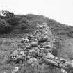
Trench IX was located across one of several low mounds. Excavations were incomplete but exposed stones were interpreted as being either a robbed-out Bronze Age cairn, or a stone dump. The discovery of a higher than usual proportion of water-worn quartz pebbles adds weight to the former interpretation.
Archive: Dunbeath Heritage Centre
Funder: Historic Scotland, HIE (CASE) and Strathmartine Trust
Lloyd Laing – University of Nottingham
Ground Penetrating Radar (June 2009)
ND 1567 3035 A GPR survey using a 270 MHz antenna was undertaken over four small areas around the supposed monastic site at Ballachly in June 2009. Several anomalies of potential interest were identified, the most prominent of which was what appears to be a large palaeo-channel running beneath one of the substantial walls. The character of this anomaly indicates that this natural feature may have been re-cut or improved and used as a site boundary. Other anomalies appear to relate to the foundations of one of the large walls found on the site and to a large circular feature of unknown function.
Archive: OCGU
Funder: University of Nottingham
Mary Saunders – Orkney College Geophysics Unit
Excavation (20 June 2009 - 22 July 2009)
ND 1567 3035 The 20 June–22 July 2009 excavations suggested that the presumed monastery at Ballachly was
focused on the low-lying ground between Chapel Hill and the river, where a church and graveyard are marked on the 1st Edition OS survey map, 1872. It is believed that this was demarcated first by a ditch which made use of an earlier watercourse, and was subsequently filled in and replaced by a substantial stone precinct wall, possibly in the Norse period. However, Chapel Hill may have had an outlying association with the monastery, as the clearance at the W end suggested that there was a dry stone square building containing a feature composed of upright slabs with slab flooring. This is very tentatively identified as a baptistery, though other
interpretations are possible. A fragment of probably early medieval sculpture came from this structure. This building was subsequently twice extended, and a further insubstantial sub-rectangular structure was constructed to the E end of the hill, though no dating evidence is yet available for these buildings. In the later Middle Ages the enclosing wall was partially demolished, the ground behind being built up to provide a surface where ironworking was carried out. On top of this surface Wall A was built, though probably not before the 16th century. The evidence for later medieval and post-medieval activity on the site is presumed to relate to the establishment here of Magnusburgh, a burgh of barony documented in the early 17th century.
Trench IV This trench, initially excavated in 2008, was extended to an area 8 x 5m with the aim of examining the
nature of the wall encountered in 2008 and the associated overlying features. This wall had been found to be running at an angle to and below the foundation level of Wall A, one of the main visible features on the site. Excavation showed that this lower wall was not, as presumed in 2008, part of a building but was a well-constructed linear feature which survived to a height of up to four courses (c0.6m) and was on average 1m wide. It was built on a deposit of sandy silt which continued to be deposited after the wall had been erected.
In the light of GPR and other geophysical survey undertaken before the excavation, this deposit probably represented the filling of a ditch, the slope of which was very gentle in front of the wall but which GPR suggested was steeper at the bottom, and in which stones had been dumped. It is possible that this was in fact an old watercourse which was later enhanced to form a ditch. This feature mostly lay outside the excavated
area, where it was not possible to examine more than the top edge. It would seem, however, that a spread of stones had been used as a partial revetment on the top edge of this ditch, a feature previously noted when the ditch was encountered in Trench VI.
The wall appears to have been deliberately slighted, a dump of stones and gravel being used to bring the area
behind the wall up to the level of the old (mostly gravel) ground surface. This make-up is presumed to have been deposited when the wall was demolished to the level of the natural ground surface, back from the line of the ditch / watercourse, to bring the whole area to the same level. Some of the stones used behind the wall were very substantial. The largest may have been naturally deposited and pre-date the build-up, but one (1 x 0.9m) was clearly deposited by human agency, as there appeared to be disturbed material underneath it.
On the surface, there were shallow hearths both in front of and behind the line of the underlying wall, one 0.6m and one 0.3m in diameter, which had fill including late Norse and late medieval wheel-turned pottery, as well as charcoal. In the top of the make-up behind the wall was a roughly circular lump of clay, which appeared to be the displaced bottom of a furnace or hearth, fired to a considerable temperature then cooled slowly. It is presumed that this relates to the ironworking apparently conducted on the artificially levelled ground surface. Finds from this surface also included pre- Norse (late Iron Age) pot sherds, slag, and an iron (presumed late medieval) hinge. Radiocarbon dates derived from this occupation level in 2008 indicate activity in the 14th to 15th century.
The current interpretation of the general sequence of events is that the ditch, probably a recut watercourse, was used to define a monastic enclosure (a radiocarbon date from another section that went across it in Trench VI in 2008 suggested it was open around AD 1000), but that this was later replaced by a substantial stone wall following the line, demarcating the monastic area which must have lain to the W, between Chapel Hill and the river. Charcoal samples for radiocarbon dating have been obtained from the top of the silt on which the wall stands, and from immediately on top of the stones of the truncated wall, which should help to refine the date of its construction, currently presumed to lie somewhere between AD 1000–1400.
Trench V This was dug partly to see if what appeared as a cropmark in 1968 was an archaeological feature and to establish if the edge of the ditch extended this far E. There was no evidence for the ditch. At the W end, however, there was some evidence of human activity in the form of a piece of copper alloy waste material, which may be a possible sprue from a mould ingate, and small sherds of pre-Norse pottery.
Trench VI Extension It was apparent that while Trench VI had encountered the ditch, any features such as the
continuing line of the replacement wall lay immediately to the W of the end of the cutting. The Trench was therefore extended. Although much less well preserved at this point, the base of the wall was encountered, with a relatively level area between it and the ditch, about 1m wide. What appeared to be possibly a second, narrower wall (c0.5m wide) was built between the main wall and the ditch, about 0.3m from the main wall. At present, no explanation can be offered for this feature.
Trench VII Extension This trench, excavated in 2008, was extended W to an area 2 x 3m, since reconsideration
of the geophysical survey suggested there might be a wall, just beyond the limit of the 2008 excavation. This extension, however, indicated that this anomaly was caused by a natural deposit of stones, with no evidence for human activity, although pre-Norse pottery was found at the base of the overlying ploughsoil.
In addition to these trenches, two investigative trenches were dug outside the scheduled area, to see if there was evidence of human activity where geophysical survey suggested there was none.
Trench X This was dug (10 x 2m) on the platform at the base of Chapel Hill. Natural sand and gravel was recorded below the topsoil.
Trench XI This was dug (3 x 2m) to the N of Chapel Hill and N of Wall B. Ploughsoil extended unevenly to a depth
of about 0.3m, with naturally deposited sand, gravel and stones below. At its southern end there was evidence of an occupation level above the natural, indicated by charcoal and a fragment of possibly early medieval window glass.
Trench XIII This 2 x 2m sondage was dug at the base of Wall A, where it had been robbed to ground level, and
revealed that Wall A appears to have been built on the same occupation deposit that lay on top of the natural in Trench IV.
Chapel Hill – Trench XII Work on top of the hill involved clearance of tumble from an area coinciding with the putative ‘chapel’, 11 x 8m, and a second smaller area coinciding with a ‘circular’ feature noted in earlier surveys, 5 x 5m. These two areas were joined by a strip, intended possibly to indicate the association of both features.
The ‘chapel’ was a structure that had been modified at least twice, and for which the original interpretation seemed unlikely. At the W end of the hill a dry stone square structure had been built, 5.2 x 4.6m externally, with walls about 0.8m wide, with an entrance in the SE corner, 0.8m wide (Structure A). This entrance had a stone threshold slab, apparently overlying the cobbles on Structure B. Structure A survived to a height of about five courses, or 0.8m in height, and had a clay floor. Only the E sector of the building was cleared of tumble, but it was found that in the NE angle of the building a slab lined feature had been constructed, c2 x 1.5m, composed of upright slabs and with a slab floor. The largest of these uprights was about 0.4m long and 0.06m wide, and
rose to a height of c0.4m above the floor level. An incised fragment of sculpture was also associated with Structure A. This building’s E wall seems at some stage to have slumped, and was extended with a further dry stone annexe with a partially cobbled floor, enclosing an area about 2.5m across (Structure B). However, this structure was mostly not cleared of tumble.
A further extension to the building (Structure C) was c2.2m long and at least 2.6m wide, the E wall formed by the cross wall (Structure D, below) which overlay the cobbles, suggesting that this was itself a later addition. This annexe is of different construction to the structures to the W, involving the use of uprights, and it appears to have had a southern entrance. Although not cleared for its whole length, a crosswall (Structure D) about 0.4m high and 0.71m wide seemed to cross Chapel Hill, although only 2m was exposed. It was composed of stones of varying form up to 0.5m long and is set on cobbles to the W and on gravel to the E, clearly postdating
Structure C.
At the extreme NE end of the cleared area an insubstantial structure was encountered, slightly trapezoidal (Structure E), 2.86 by 1.2m (possibly up to 1.9m) internally (the end having been robbed out), comprising a single thickness of stones with up to three courses surviving. This appeared to be open at the NE (short) side, and its function and date are unknown, although in front was a line of what appeared to be paving.
Archive: Dunbeath Heritage Centre
Funder: Historic Scotland, HIE (CASE) and Strathmartine Trust
Lloyd Laing – University of Nottingham
Excavation (24 June 2010 - 26 July 2010)
ND 1567 3035 The final season of excavations on the medieval site at Ballachly was undertaken 24 June–26 July 2010 by a team from the University of Nottingham, with help from volunteers. The season saw the completion of work on the features on Chapel Hill and further excavation in the area to its W.
Trench XII–XIV
The area on Chapel Hill opened in 2009 (Trench XII) was partially reopened. Here a rectangular drystone building (Building A) partly excavated in 2009, was cleared down to floor level. There was no evidence for domestic occupation, which may indicate that it could have been ecclesiastical, possibly a baptistery. No dating evidence was recovered, but features of its construction (including floor of clay mixed with peat and stones pieces, and the slab-lined box-like feature investigated in 2009), would be in keeping with a Late Norse (probably 12th-century) date. This building had been extended, as was demonstrated in 2009, probably to form the longer structure documented as a ‘priest’s house’ in later accounts.
An extension to this trench was made W towards the edge of the summit of Chapel Hill, initially comprising an area 11 x 8m, and later extended to examine some features encountered within the area (Trench XIV). It was established that Building A, which had an approximate E–W orientation, was built partly on top of a large, cobbled area on a different axis, the cobbles being removed inside the structure but visible within the wall makeup. This cobbled area (10.4x 3.4m) was cambered to a central slab-lined culvert and extended to the edge of the hill. There is no evidence for its purpose, but it may have been for the collection of water, which considering the Early Christian evidence found nearby, could indicate a monastic function. Adjacent to it were two rectangular, slab-defined features (context 1421, 1.1 x 1.3mand context 1412, 1.1 x 1.2m), one of which (context 1421) displayed evidence for intense heat, suggesting its use as a hearth, possibly for metalworking. This was partly overlain by a stone wall. The second structure (context 1412) showed no evidence for burning, but it is probable that this was also a hearth and that such evidence was eroded, due to the thin topsoil covering this area. A further wall 1.6m long and of an unknown width, (context 1414) showed evidence of rotational collapse. There were other partial stone alignments suggesting a semi-circular feature adjacent to the probable hearths (context 1424, c1.4 x 1.6m), as well as what were interpreted as post-pads for timber structures (contexts1410 and 1411). Finds were extremely sparse but included fragments of ‘Pictish’ (Late Iron Age) pottery, compatible with the use of the summit in the early medieval period. The features found were comparable with those from other early monastic sites in Scotland, such as Portmahomack (Ross)and Inchmarnock and Kingarth (Bute). A number of worked flints were found which appear to be of Mesolithic date but could have been re-used at the site in the early and later medieval periods.
Trenches XV and XVI
Two sondages were dug in the area to the NW of Trench VI, initially 2 x 2m, of which one(XV) was subsequently extended by 1m S and 1 x 1m E, to form an L shaped sondage. These were intended to locate the chapel indicated on the 1st Edition OS map of 1872 but were unsuccessful in this, producing evidence for the early19th-century flooding which traditionally removed the chapel and associated burials. A piece of what appears to have been late medieval window glass was recovered in Trench XV and there was some evidence for the former existence of long-cist graves in Trench XVI, largely washed away, in the form of flat slabs.
Trenches XVIII and XIX
Further investigation of the ditch and enclosing wall, believed to have defined the second phase of the site, was undertaken to the SE of Wall A, between Wall A and Trench III (excavated in 2008). Trench XIX, which measured 2 x 2m, was found to be filled with deposited stones and gravel from the episodes of flooding. This was adjacent to the SW extent of Trench XVIII where the wall previously encountered in Trench IV had been reduced to some large stones no longer in situ. The edge of the ditch was reached at a depth 0.7m, indicating a width at the top of 2.8m. Excavation was discontinued at this point for health and safety reasons, as time did not permit the construction of shuttering. Finds from the overlying deposits included Late Iron Age, Late Norse and later medieval wheel-made pottery, and some ironwork and a whetstone, presumably strays from the late medieval ironworking investigated to the NW of Wall A in 2009.
Archive: Dunbeath Heritage Trust Funder: Historic Scotland; HIE Caithness and Sutherland Enterprise

