
Pricing Change
New pricing for orders of material from this site will come into place shortly. Charges for supply of digital images, digitisation on demand, prints and licensing will be altered.
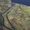
Fort William - Fort Augustus - Inverness Military Road


Military Road (18th Century)
Site Name Fort William - Fort Augustus - Inverness Military Road
Classification Military Road (18th Century)
Canmore ID 81106
Site Number NH30NE 20
NGR NH 3734 0800
NGR Description NH 3540 0500 to NH 3999 0900
Datum OSGB36 - NGR
Permalink http://canmore.org.uk/site/81106


- Council Highland
- Parish Boleskine And Abertarff
- Former Region Highland
- Former District Inverness
- Former County Inverness-shire
NH30NE 20.00 3540 0500 to 3999 0900 MR 1
NH30NE 20.01 NH 3924 0861 Drainage feature
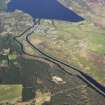
NH 3539 0500 - 3796 0905 A82 on line of Wade's road, though there are intermittent traces of an early road higher up on the E side to the S of Loch Vanagan. The road probably entered the 1716 fort (or barracks) of Killichuimen (NH30NE 5) - the site of which is now occupied by the Lovat Arms Hotel (NH 3780 0906) as the building of Fort Augustus (NH30NE 6) was not commenced until 1727 and completed in 1742.
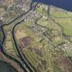
NH 3796 0905 - 3884 0842 B862 on line of Wade road.
NH 3884 0842 - 3999 0900 The road leaves the B862 for some 200m as a farm track and then continues as a disused grass track through a conifer plantation to NH 3951 0876 to where it crosses the B862 and appears on the E side as a grass-covered track, until it merges with the B862 at NH 3992 0901.
Visited by OS June 1964; February 1979.
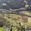
It is believed that the military road heading N to Fort Augustus is overlain by the A82. Although Taylor (1976) comments that traces of an earlier road are visible up to the E of the modern road, basically the only military characteristic of this track lies in the fact that it is 3m to 4m wide.
In Fort Augustus are the remains of the 1718 Kiliwhimin Fort and Barracks (NH30NE 5) at NH 3777 0905 and the military barracks of Fort Augustus, incorporated in St. Benedict?s Abbey (NH30NE 6) at NH 3818 0914.
The military road heads E from Fort Augustus, being overlain for much of its route to the E of Loch Ness by the B862. However, at NH 3885 0841, the route diverges from that of the modern road, taking the form of a rough stony track running past a cottage and passing through a conifer plantation further E. To the E of this cottage the track becomes rougher and more overgrown, and down its E side there lies a shallow ditch. Vehicles using this route, presumably in connection with tree felling, have caused quite severe damage in this area.
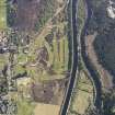
Further along this section, a burn has eroded through the track fabric, and iron plates (NH30NE 20.01) have been placed across the S side of this area at NH 3924 0861 in an effort to prevent further erosion. Above this the burn runs down the E side of the track, eating into the side of the road. There has also been encroachment onto the route by tree planting in this area. Approximately 70m above the burn crossing the track widens out into a flat depression, measuring 4m to 5m wide between banks. Debris from tree felling covers the N end of this section of the track and the ground suffers from a certain amount of plant damage. Further E the military road is cut by the B862, the route reappearing in the form of a rough grass-covered track. This track runs through uncultivated land parallel with the E side of the B862 and displays no obvious military features. It rejoins the modern road at NH 3995 0901.
M Logie (Highland Council) 1997; NMRS, MS/1007/3.

