
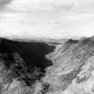
Gleann Meinich


Dyke (Period Unassigned), Enclosure (Period Unassigned), Farmstead (Period Unassigned), House (Period Unassigned), Pen (Period Unassigned)
Site Name Gleann Meinich
Classification Dyke (Period Unassigned), Enclosure (Period Unassigned), Farmstead (Period Unassigned), House (Period Unassigned), Pen (Period Unassigned)
Alternative Name(s) Middle Gleann Meinich, Allt A Chair, Calums Croft
Canmore ID 80844
Site Number NH25SE 9
NGR NH 2535 5370
Datum OSGB36 - NGR
Permalink http://canmore.org.uk/site/80844


- Council Highland
- Parish Contin
- Former Region Highland
- Former District Ross And Cromarty
- Former County Ross And Cromarty
NH25SE 9 2535 5373.
'19th century gillie's house ('Calum's Croft') and dyke': no details given.
D W Ross 1991a.
A rectangular building measuring 13.3m by 4.9m with internal division, rubble-built and ruinous. A rubble-built dyke runs from house toward river for c.50m, and stands up to 1m in height.
NMRS MS/1131/20 no. 8.7, figs 8.7
Srp Note (24 January 2011)
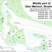
The remains of a well-constructed rectangular building 'Calum's Croft' (NOSAS survey site Nos 985), an enclosure (986) and a lambing pen (984) located in a sheltered position on the E side of the fluvial outwash of the Allt a’Chair with evidence of improved ground to the NE.
Further details of these and other associated sites can be found in the Strathconon Phase 4 Report (page26) produced by the North of Scotland Archaeology Society and appended to this record.

