
Fordoun Airfield


Airfield (20th Century)
Site Name Fordoun Airfield
Classification Airfield (20th Century)
Alternative Name(s) Fordoun Flying Club
Canmore ID 80732
Site Number NO77NE 63
NGR NO 7514 7707
NGR Description Centred NO 7514 7707
Datum OSGB36 - NGR
Permalink http://canmore.org.uk/site/80732


- Council Aberdeenshire
- Parish Fordoun
- Former Region Grampian
- Former District Kincardine And Deeside
- Former County Kincardineshire
NO77NE 63.00 centred 7514 7707
The airfield and dispersed sites falls partly on Map sheet NO77NW, for other elements of the airfield see NO77NW 180.00
NO77NE 63.01 NO 75747 77164 and NO 75834 77129 Aircraft Hangars
NO77NE 63.02 centred NO 7550 7780 Dispersal Bays
NO77NE 63.03 NO 75261 77796 and NO 75534 77796 Aircraft Hangars; Dispersal Bays; Huts
Fordoun Flying Club [NAT]
OS 1:10,000 map, 1992.
Fordoun was built as the two runway satellite of Peterhead (NK04NE 12). During 1944, flying was stopped, as the concrete runways were cracking badly and temporary repairs had to be made.
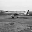
Fordoun was re-opened for private flying in 1965, and a road now follows the line of one of the runways, but all four Blister hangars have survived, one roofless, and other buildings including the parachute store still stand.
D J Smith 1983.
Many airfield structures still extant; most of site returned to agricultural land.
Information from Mr J Guy, visited 10 June 1992.
NMRS, MS/712/8.
Air photographs: AAS/97/03/G4/15-19 and AAS/97/03/CT.
NMRS, MS/712/29.
The airfield is visible on vertical air photographs taken in 1946 (106G/Scot/UK 62, 4335-4339, flown 8 May 1946), and show that at this date the runways had been blocked with short barriers. The flying area of the airfield, excluding the domestic and technical sites, is about 93 hectares
The air photographs also show the dispersed domestic (accommodation) sites to the W in the area to the NW of Redhall House (NO77NW 48) and the technical area (NO77NW 180.01) with the control tower (NO77NW 180.04) on the western side of the airfield.
The control tower has been demolished, but many domestic buildings and at least three of the blister type aircraft hangars survive around the airfield. The runways are still extant and several agricultural buildings have been placed or constructed on them. One hangar site is shown vacant on the current OS 1:2500 scale digital map.
Information from RCAHMS (DE), November 2005
Watching Brief (21 October 2014)
Standard CFA watching brief report with descriptive narrative supported by a plan of the area monitored and a set of photographs. The watching brief was undertaken to monitor ground-works for a single wind turbine at Fordoun Sawmill, Fordoun, Aberdeenshire. No features, deposits or artefacts of archaeological significance were identified during the watching brief.
Information from OASIS ID: cfaarcha1-194434 (M Kirby) 2014

