
Pricing Change
New pricing for orders of material from this site will come into place shortly. Charges for supply of digital images, digitisation on demand, prints and licensing will be altered.
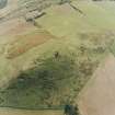
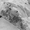
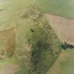
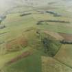
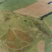
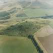
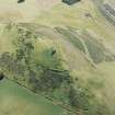
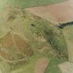
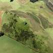
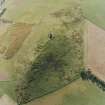
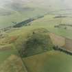
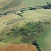
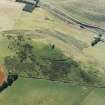
Dunnideer


Rig And Furrow (Medieval) - (Post Medieval)
Site Name Dunnideer
Classification Rig And Furrow (Medieval) - (Post Medieval)
Canmore ID 80719
Site Number NJ62NW 52
NGR NJ 6143 2812
NGR Description Centred NJ 6143 2812
Datum OSGB36 - NGR
Permalink http://canmore.org.uk/site/80719


- Council Aberdeenshire
- Parish Insch
- Former Region Grampian
- Former District Gordon
- Former County Aberdeenshire
NJ62NW 52 centred 6143 2812
(Location cited as NJ 614 282). A area of rig-and-furrow cultivation is visible on air photographs AAS/94/02/G4/9-12, flown 8 February 1994. (Copies held by Grampian Regional Council).
M Greig 1994; NMRS, MS/712/6 and MS/712/21.
(Location amended to centred NJ 6143 2812). The remains of rig-and-furrow cultivation are visible on the E flank of the Hill of Dunnideer, dropping down from the line of the outer defences of the fort (NJ62NW 1) to the boundary of the improved ground further down the slope. The rigs measure up to 10m in breadth and are aligned roughly ENE and WSW.
Visited by RCAHMS (JRS), 25 May 1999.
This site, and others on Dunnideer Hill, was affected by a fire that spread across the grass and exposed archaeological features, including pottery and other materials. Historic Scotland funded a project to assess the damage the fire did to the upstanding archaeology, and any remains exposed by it or the fire brigade's work (they stripped turf in an attempt to contain the spreading fire).
S Badger2006

