
Langwell Castle


Castle (Medieval)
Site Name Langwell Castle
Classification Castle (Medieval)
Alternative Name(s) Achastle; Langwell House
Canmore ID 8071
Site Number ND12SW 13
NGR ND 1162 2271
Datum OSGB36 - NGR
Permalink http://canmore.org.uk/site/8071


- Council Highland
- Parish Latheron
- Former Region Highland
- Former District Caithness
- Former County Caithness
ND12SW 13 1162 2271
(ND 1162 2271) Langwell Castle (NR) (Ruin)
OS 6" map, Caithness, 2nd ed., (1908)
Achastle (NR) (remains of)
OS 6" map, (1964)
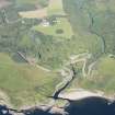
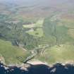
At the foot of the park in front of Langwell House are the scanty ruins of Achastle. It seems to have been a large rectangular keep, measuring some 70 by 43ft internally, with a projecting turret at the NW angle. Some 26ft of the N wall remains to a height of about 10ft, with a thickness of 5ft 6ins. The interior is full of ruins. The castle has stood at the extremity of the high ridge forming the watershed between the waters of Berriedale and Langwell, and on the N and W, where not protected by steep banks, it has been flanked by a broad, deep ditch. The ruin is mentioned about 1726 (Macfarlane 1906-8) as 'an antient fabrick, a part whereof stands yet'; while Cordiner (1788) shows the ruin (about 1788) as consisting of two square towers connected by a curtain wall, crowning the cliffs above the junction of the streams. In the OSA (1796) it is said to have been built and possessed by John Beg, third son to the Earl of Sutherland.
C Cordiner 1788; Statistical Account (OSA) 1796; W Macfarlane 1906-8; RCAHMS 1911.
Achastle or Langwell Castle: Generally as described by the RCAHMS. In addition to the NW angle turret, the outline of a similar one can be traced at the NE angle. The interior of the keep is a mass of rubble overgrown with weeds. A causeway (2.8m wide) crosses the ditch at the NW angle. The ditch is some 11.5m wide and 4.0m maximum depth, with much stone scattered along its scarps.
Visited by OS (W D J), 4 July 1960.
Langwell Castle (information from the Factor, Langwell Estate Office) is as described, except that the walling has tumbled further and is now only 1.5m high.
Resurveyed at 1:2500.
Visited by OS (R L), 29 February 1968.
(ND 1162 2271) Langwell Castle (NR) (remains of)
OS 25" map, (1969)
No change to the report by the previous OS field surveyor.
Visited by OS (J M), 23 November 1982.

