
Pricing Change
New pricing for orders of material from this site will come into place shortly. Charges for supply of digital images, digitisation on demand, prints and licensing will be altered.
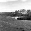
Dunbeath Bridge


Road Bridge (19th Century)
Site Name Dunbeath Bridge
Classification Road Bridge (19th Century)
Alternative Name(s) Dunbeath Water; Dunbeath, Old Bridge
Canmore ID 8038
Site Number ND12NE 9
NGR ND 15994 29852
Datum OSGB36 - NGR
Permalink http://canmore.org.uk/site/8038


- Council Highland
- Parish Latheron
- Former Region Highland
- Former District Caithness
- Former County Caithness
ND12NE 9 15994 29852
For successor and present bridge (to SSE), see ND12NE 40.
(Location cited as ND 160 298). Bridge, Dunbeath, built 1809-13 by engineer Thomas Telford. A single segmental masonry arch.
J R Hume 1977.
Dunbeath Bridge was built in 1813 and is a typical Parliamentary bridge of medium size, having a span of 60ft (18.3m). The arch is low and segmental, and the abutments are slightly battered with dressed voussoirs.
G Nelson 1990.
This bridge carries the former line of the A9 public road over the Dunbeath Water to the W of Dunbeath village (ND12NE 15).
Information from RCAHMS (RJCM), 6 May 1998.

