
Fullerton


Cropmark(S) (Period Unknown), Promontory Fort (Period Unassigned), Ring Ditch(S) (Period Unassigned)
Site Name Fullerton
Classification Cropmark(S) (Period Unknown), Promontory Fort (Period Unassigned), Ring Ditch(S) (Period Unassigned)
Canmore ID 80019
Site Number NJ71NE 97
NGR NJ 7810 1840
Datum OSGB36 - NGR
Permalink http://canmore.org.uk/site/80019


- Council Aberdeenshire
- Parish Kintore
- Former Region Grampian
- Former District Gordon
- Former County Aberdeenshire
NJ71NE 97 781 184
For other cropmark sites nearby seee:
NJ71NE 74 7843 1797 Fullerton enclosure
NJ71NE 75 7838 1817 Fowlertown Cottage enclosure
NJ71NE 96 7836 1797 Fullerton pit-alignment
NJ71NE 97 781 184 Fullerton fort; ring-ditches
NJ71NE 98 7846 1798 Fullerton ring-ditch; cropmarks
NJ71NE 100 7830 1780 Fullerton enclosure
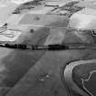
Vertical and oblique air photography have recorded cropmarks on a promontory at an altitude of about 55m OD; the area was formerly under cultivation and material was dumped onto it in August 1992. Two penannular ring-ditches have been identified within the triangular area enclosed by a promontory fort, which is itself defined by long curvilinear traces. There are other curvilinear cropmarks nearby.
(Air phototographic imagery: CUCAP CAF 17-18, flown 21 July 1976 and BKS NJ71N 27292050, flown 7 July 1977).
NMRS, MS/712/67.
Note (22 April 2015 - 18 May 2016)
Parchmarks have revealed what may be a fort cutting off a promontory formed between the escarpment bordering the floodplain of the River Don on the NE and a shallow gully on the SW. The NE margin of the promontory has also been clipped by the excavation of a cutting for the railway, and since the photographs were taken the surrounding area has been taken up with industrial developments and the vegetation on the fort itself has reverted to scrub. The ditch, which measures about 3m in breadth and towards the NE is accompanied internally by a possible palisade trench, bars the approach from the NW. The entrance is on the NW, about 20m short of the SW margin of the promontory; the terminals of the ditches turn slightly inwards to either side, but the palisade trench appears to carry across the gap unbroken. The triangular interior, which measures about 95m from NW to SE by 60m transversely immediately to the rear of the defences (0.32ha), contains two crescentic features, one of which almost certainly marks the position of a timber round-house, while the the other is either a round-house or a small souterrain.
Information from An Atlas of Hillforts of Great Britain and Ireland – 18 May 2016. Atlas of Hillforts SC2966

