
Perth, East Railway Bridge


Railway Bridge (19th Century)
Site Name Perth, East Railway Bridge
Classification Railway Bridge (19th Century)
Alternative Name(s) Friarton Island; Moncrieffe Island; River Tay; Tay Railway Viaduct
Canmore ID 79827
Site Number NO12SW 268
NGR NO 12335 22956
Datum OSGB36 - NGR
Permalink http://canmore.org.uk/site/79827


- Council Perth And Kinross
- Parish Kinnoull
- Former Region Tayside
- Former District Perth And Kinross
- Former County Perthshire
NO12SW 268 12335 22956
Location formerly cited as NO 1228 2302 to NO 1235 2287.
For description and bibliographic references, see under Perth, River Tay, West Railway Bridge (NO12SW 267).
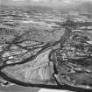
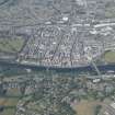
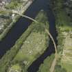
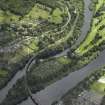
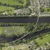
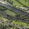
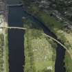
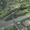
This curving bridge forms the E half of the composite structure that carries the Perth-Dundee railway line from Perth (to the W) to Barnhiil (to the E) across (in succession from the W) Shore Road, the western channel of the River Tay, Friarton or Moncrieffe Island, and the eastern channel of the River Tay. It remains in regular use by passenger traffic.
This bridge crosses the eastern channel of the River Tay, and falls entirely within the parish of Kinnoull, as does Friarton or Moncrieffe Island. It is depicted. but not noted, on the 1994 edition of the OS 1:10,000 map.
The location assigned to this record defines the centre of the river span. On the basis of the available map evidence, the structure may be considered to extend from NO c. 12228 23085 to NO c. 12367 22856. The defined transition point between this bridge and that (NO12SW 267) to the NW is essentially arbitrary.
Information from RCAHMS (RJCM), 31 May 2006.

