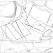
|
Photographs and Off-line Digital Images |
B 79401 |
RCAHMS Aerial Photography |
Oblique aerial view. |
1992 |
Item Level |
|
|
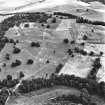
Photographs and Off-line Digital Images |
B 79404 |
RCAHMS Aerial Photography |
Oblique aerial view. |
1992 |
Item Level |
|
|
Photographs and Off-line Digital Images |
PT 154 |
|
Excavation photograph: section of W ditch of riverside stores compound showing ditch filled and covered by gravel surface |
1961 |
Item Level |
|
 |
On-line Digital Images |
SC 355768 |
Records of the Royal Commission on the Ancient and Historical Monuments of Scotland (RCAHMS), Edinbu |
Publication drawing; Inchtuthil, general plan of the plateau |
1992 |
Item Level |
|
|
Prints and Drawings |
DC 37409 |
Papers of Professor John Kenneth Sinclair St Joseph, archaeologist, Histon, Cambridgeshire, England |
Inchtuthill - Contour map of local area |
|
Item Level |
|
|
Prints and Drawings |
DC 37410 |
Papers of Professor John Kenneth Sinclair St Joseph, archaeologist, Histon, Cambridgeshire, England |
Inchtuthill - Contour map of local area. |
|
Item Level |
|
|
Prints and Drawings |
DC 37417 |
Papers of Professor John Kenneth Sinclair St Joseph, archaeologist, Histon, Cambridgeshire, England |
Inchtuthill.
Plan of redoubt, by DRW after I A Richmond. |
1965 |
Item Level |
|
|
Prints and Drawings |
DC 37452 |
Papers of Professor John Kenneth Sinclair St Joseph, archaeologist, Histon, Cambridgeshire, England |
Inchtuthill.
Plan of fortress and temporary camps. |
|
Item Level |
|
 |
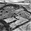
On-line Digital Images |
SC 1709237 |
RCAHMS Aerial Photography |
Oblique aerial view. |
1992 |
Item Level |
|
 |
On-line Digital Images |
SC 1709239 |
RCAHMS Aerial Photography |
Oblique aerial view. |
1992 |
Item Level |
|
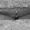 |
On-line Digital Images |
SC 2575291 |
|
Excavation photograph: section of W ditch of riverside stores compound showing ditch filled and covered by gravel surface |
1961 |
Item Level |
|


