
Rosyth, Hm Dockyard


Crane(S) (20th Century), Naval Dockyard (20th Century), Naval Dockyard (First World War)
Site Name Rosyth, Hm Dockyard
Classification Crane(S) (20th Century), Naval Dockyard (20th Century), Naval Dockyard (First World War)
Alternative Name(s) Rosyth Royal Dockyard; Babcock Thorn; Fleet Maintenance Group; Hm Naval Base Rosyth
Canmore ID 79567
Site Number NT08SE 41
NGR NT 0986 8267
NGR Description Centred NT 0986 8267
Datum OSGB36 - NGR
Permalink http://canmore.org.uk/site/79567


First 100 images shown. See the Collections panel (below) for a link to all digital images.
- Council Fife
- Parish Dunfermline
- Former Region Fife
- Former District Dunfermline
- Former County Fife
NT08SE 41.00 centred 0986 8267
Rosyth Royal Dockyard [NAT] (name cited at various locations)
OS (GIS) AIB, April 2006.
Extends onto map sheet NT18SW.
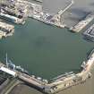
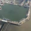
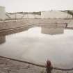
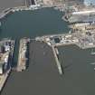
NT08SE 41.01 Centred NT 0960 8210 Main basin (non-tidal)
NT08SE 41.02 NT 0973 8180 to 0997 8188 Entrance lock
NT08SE 41.03 NT 0965 8226 to 0977 8255 no. 1 dry dock
NT08SE 41.04 NT 0974 8222 to 0984 8247 no. 2 dry dock
NT08SE 41.05 NT 0983 8219 to 0992 8243 no. 3 dry dock
NT08SE 41.06 Centred NT 0953 8240 Synchrolift
NT08SE 41.07 NT 09974 82331 Electricity generating station
NT08SE 41.08 NT 0993 8221 Pumping station
NT08SE 41.09 NT 0893 8322 Barrage Balloon site
NT08SE 41.10 NT 0948 8339 Barrage Balloon site
NT08SE 41.11 NT 0951 8238 Barrage Balloon site
NT08SE 41.12 NT 0883 8325 Pillbox (possible)
For unidentified shipwreck at NT 1192 8007, see NT18SW 8010.
See also:
NT18SW 212 Centred NT 115 820 POL depot and tank farm
NT18SW 213 Centred NT 0101 8213 Tidal Basin
NT18SW 214 NT 1011 8188 to NT 0991 8195 Middle pier
NT18SW 215 NT 1037 8197 to NT 1092 8175 North Wall (HMS Safeguard)
NT18SW 252 NT 1020 8209 Boat house
NT18SW 253 NT c. 1021 8225 Electricity sub-station
For Rosyth Castle (NT 1087 8210), dovecot (NT 1102 8223) and Chapel of St Andrew (NT 0997 8218), see NT18SW 20.00, NT18SW 20.01, NT18SW 57 respectively. All these monuments stand within the dock estate.
For stone axe found within the dockyard area, see NT18SW 83.
For associated ammunition depot (RNAD Crombie), see NT08SW 104.00.
The Admiralty acquired land for the proposed Naval Base at Rosyth in 1903. Various plans for the Base appear to have been considered, and eventually in the Spring of 1903, there were issued particulars of the scheme approved, to be executed at an estimated cost of £3,000,000. Of this scheme, which locates the work some distance W of Rosyth Castle (NT18SW 20.00), the main features are:
a. basin area 52.5 acres (21.6ha) with projecting pier, giving a total wharfage of 7108 ft (2167m) and a depth of water of 38ft 8ins (11.8m),
b. entrance lock on the site of the Dhu Craig rock, available for use as a dock: 850 ft (259m) long, 110 ft (33.5m) wide at the entrances, and 36 ft (11m) deep over the sill at low water spring tides,
c. a straight river wharf 2733 ft (833m) long with 36 ft (11m) depth of water at low water neap tides; this wharfage is carried sufficiently deep to allow berths to be ultimately dredged to 36 ft (11m) deep over the sill at low water spring tides,
d. emergency exit, 110 ft (33.5m) wide, from the basin, with depth similar to the basin,
e. space for stacking coal on ground S of the entrance lock,
f. dry dock, 750 ft (228.7m) long, 100 ft (30.5m) wide at the entrance and with 36 ft (11m) depth of water over the sill. This can be subdivided for use as two seperate dry docks, measuring 450 ft (137m) and 280 ft (85.4m) in length respectively,
g. boat slip, 200 ft (61m) by 130 ft (39.6m), one half of which is covered with light roofing,
h. basin for submarine boats and temporarily for destroyers, 600 ft (183m) by 470 ft (143.3m) with a depth of 15 ft (4.6m) at low water spring tides. A floating dock 250 ft (76.2m) long will be provided, together with jetties for 12 submarines and 6 destroyers,
i. an approach channel to the entrance lock, dredged to a depth of 38 ft (11.6m) at low water spring tides and a bottom width of 1050 ft (320m),
j. railways of the ordinary gauge to connect up with the North British Rly's system by a branch line, which, constructed in 1905-6, starts from the Dunfermline-Queensferry railway at a point near Jamestown and running westward terminates a short distance W of Rosyth Castle,
k. the usual equipment of railways, cranes etc. and also workshops, storehouses and residences for officers. Electric light and power will be provided for the whole of the establishment.
Reserve space is provided for two future docks parallel with the one proposed. The scheme is so drawn up that it may fit into any larger plan that may afterwards be deemed necessary.
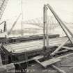
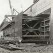
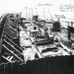
The contract for the work was secured by Messrs. Easton Gibb and Son Ltd, Westminster, who began operations in the month of March 1909. It is stipulated that the work be completed in seven years, a substantial bonus being offered for early completion.
On 19 July 1910 it was announced in the House of Commons that the proposed dry dock would be increased in size to the following dimensions: 850 ft (259.1m) long, 110 ft (33.5m) wide and 38 ft (11.6m) deep in the sills, and that a second dry dock of similar size would be constructed at an estimated cost of ?280,000. It is understood that a third dry dock is contemplated and that the proposed projecting pier in the basin has been abandonned.
The establishment of the Base necessitated the closing of the road along the shore of the Forth, and in lieu thereof there was constructed in 1908 a road which, branching from the shore road at a point some distance W of Hilton of Rosyth, passes eastwards along the valley by way of Blackmarch and joins the Great North Road at the N end of Chapel Place.
W Stephen 1921.
The selection of Rosyth as the site of the major naval base facing Germany was evidently based on the eminently defensible nature of its situation, with the potential for siting strong batteries on Inchkeith, Kinghorn Ness and elsewhere. For its construction, the Admiralty purchased 285 acres (115ha) of foreshore and 1,184 acres (479 ha) of hinterland from the Marquis of Linlithgow, and established the wortker's housing of 'tin town' from 1909 onwards. The base did not become fully operational until March 1916, largely on account of the problems encountered in excavating the prevailing heavy clay.
B Lenman 1975.
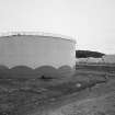
The decision to build a naval dockyard on the E coast of Scotland was taken in 1903 and the necessary land at Rosyth bought by the government. The tidal basin and two graving docks were built by Easton, Gibb and Son Ltd in 1909-14, and the oil fuel depot, with a concrete tank (for 250,000 tons) and 37 steel tanks (each for 5000 tons), in 1914. The dockyard workshops were begun in 1915.
Short-time working at the yard was introduced in 1921, and the yard closed in 1925. Reopening in 1938 was accompanied by further workshop development which continued after the second world war.
J Gifford 1988.
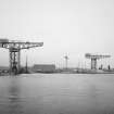
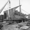
The William Arrol 100-ton and 250-ton cranes were demolished in 1992.
Information from RCAHMS (MKO), December 1992.
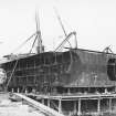
General history of shipbreaking at Rosyth and Charlestown.
Table of operating statistics (p. 49); list of ships broken at Rosyth and Charlestown 1923-63 (pp. 61-100).
Illustrations include plan of Rosyth Dockyard (p. 8), Luftwaffe air photograph (p. 40), and National Survey vertical air photograph (p. 42).
I Buxton 1992.
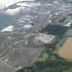
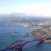
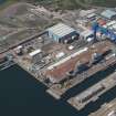
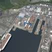
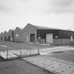
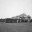
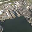
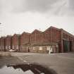
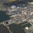
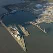
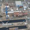
Rosyth dockyard was constructed during the early years of this century to serve specifically as a support and heavy repair base for both capital and smaller warships of the Grand Fleet which was to be forward-based in defended anchorages in the Cromarty Firth and Scapa Flow so as constrain the movements of the German High Seas Fleet from outflanking positions; it was also able to carry out construction work. The dockyard has long been the largest facility used by the Royal Navy outside southern England and has formed the centrepiece of a notable cluster of naval command, administration, logistics and support facilities (as noted above). By virtue of employing large numbers of civilian workers, it has also exerted a major influence on the social history of the area.
The base was run down after the Armistice and closed to naval use between 1928 and 1935 although at least one of the dry docks was used during this period for breaking-up ships of the High Seas Fleet that had been salvaged by Cox and Danks after their scuttling in Scapa Flow.
The period of preparation before the Second World War saw the reactivation of the base and the construction of several new facilities, notably HMS Caledonia (NT08SE 50); the base fulfilled essentially the same role in this war as in the First. With the end of hostilities, however, the base was kept in operation to support forces deployed to counter the Northern and Baltic Fleets of the Soviet Navy, its northern location being once again a distinct advantage.
The post-war years, however, saw a major shift in emphasis in the role of the dockyard on account of the steady decline in the size of the navy and specifically the continuing reduction in the numbers of the heavy surface ships which the base was built to support. At the same time, the lack of rebuilding work resulted in much of the real estate becoming decrepit and unfitted to the demands of post-conscription service personnel, many of whom remained in accommodation in hulked ships.
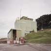
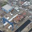
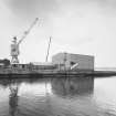
The major defence re-alignment of the late 1960's was a major turning-point for Rosyth, which was designated the major refitting base for the Polaris (strategic ballistic missile) nuclear submarine fleet, the dockyard being re-equipped to handle major servicing and refitting of the submarines and their reactors (but not the missiles and warheads). The base also remained important for the refitting and support of minor war vessels (mine countermeasures ships and patrol craft) while warships and auxiliaries of other types (and other NATO nations) visited the base for refit, resupply or in preparation for major exercises. In response to this redirection, the accommodation areas of the base saw considerable improvement, HMS Cochrane (NT18SW 216) being constructed around system-built blocks. Somewhat later, the synchrolift complex (NT08SE 41.06) was added to allow minor war vessels to be refitted under cover.
The 1970's and 1980's saw a gradual but continuous reduction in both the size of the navy and the number using Rosyth, although this trend was countered to some extent by the closure in 1976 of HMS Lochinvar, the minor war vessels base at Port Edgar (NT17NW 181.00) and the resulting transfer of ships to the main base. In the 1990's the ending of the cold war meant that the Royal Navy lost the role of countering Soviet forces to the N and E so that the geographical position of Rosyth became a liability as the navy contracted to within its southern homeland. Following considerable political protest, largely occasioned by considerations of local employment, the operational ships and most of the uniformed personnel were withdrawn between 1993 and 1996 and the base was transferred on a commercial basis to Messrs Babcock Thorn as a privatised shipbuilding, ship-repair and general engineering works with a limited guarantee of naval work for the foreseeable future.
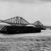
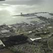
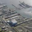
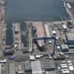
The dockyard was built out from the N shore of the Firth of Forth immediately above the rail bridge (NT17NW 70) and with ready access to the relatively deep water of the outer Forth estuary. It has ample anchorage-space in about 20m depth of water within the inner estuary (to the SW) and the entrance-channel is dredged to 8.8m. An expanse of flat ground (most of it reclaimed from saltmarsh) provides space for the various facilities, while ample space was left for possible expansion to the ESE. The layout of the massive dock structures is constrained by the Dhu Craig and Whale Back ridges to the S and SE and the universal use of floating caissons rather than fixed dock gates may indicate a need to keep the weight of structures to a minimum.
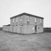
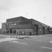
It is inevitable that a facility of this nature should be considerably more complex and extensive than would be the case in a civilian shipyard of comparable significance. The complex nature of warships requires the provision of many specialist workshops and stores to carry out what would otherwise be considered simply as 'fitting-out', while arrangements must be made to provide training, accommodation and recreation for crews of ships berthed alongside or in refit.
A brief description of the functions of specific areas during the 1970's and 1980's will illustrate this point.
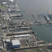
Four areas of the dockyard were used directly for the support of ships. The (non-tidal) main basin (NT08SE 41.01), its related dry docks (NT08SE 41.03-05) and the synchrolift facility (NT08SE 41.06) were used for the refitting (and in some cases laying-up) of ships and submarines which had been de-commissioned (taken out of service and without crews). Work within this area was carried out by non-uniformed (civil service) staff and private contractors. The tidal basin (NT18SW 213) was occupied by small ships which remained in commission, most work in this area being carried out by uniformed staff of the (Royal Naval) Fleet Maintenance Group. The (adjacent) area around the Middle Pier (NT18SW 214) was also tidal and was occupied by the harbour or 'yard' craft ('PAS boats') of the Royal Maritime Auxiliary Service while the North Wall (NT18SW 215) provided tidal berths for the replenishment of fleet refuelling tankers and other large ships, beside being the usual berthing point for aircraft carriers and other heavy ships.
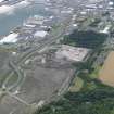
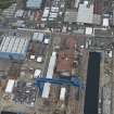
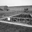
Behind the berthing facilities there was a succession of large storage facilities, the most easterly being the oil tank farm (NT18SW 212) which was evidently situated for convenient access to the North Wall. To the west (around NT 106 820) was a large area of victualling and naval stores, which was not, however, designated as a stores yard with a title as such. A large part of this area was given over to the open-air storage of such unwieldy items as mooring anchors and buoys, this relic of the boom defence trade being entitled HMS Safeguard. Training facilities in this area included the firefighting training 'fireground' with its distinctive practice 'rigs', and the Command Diving School.
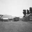
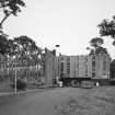
Almost all dockyard personnel lived in the surrounding communities, most particularly the prefabricated temporary accommodation ('tin city') around NT 113 833 and Rosyth garden city (NT 112 843 to 118 835). Uniformed personnel were accommodated in HMS Cochrane (NT18SW 216) and HMS Caledonia (NT08SE 50), and in extensive married quarters (NT18SW 219). Senior officers' official residences included St Margaret's Hope (NT18SW 217.00)and Admiralty House (NT18SW 218) which were provided for Flag Officer Scotland and Northern Ireland and the Admiral Superintendant of the Dockyard (latterly Port Admiral Rosyth), respectively.
Although Rosyth has never had the well-developed infrastructure of recreational and community facilities that is found at Portsmouth or Plymouth, there was an official base church (NT18SW 220) and extensive playing fields were provided (around NT 107 833); these latter facilities were presumably intended for the simultaneous organised physical recreation of very large numbers of ratings, but latterly saw very little use and have been sold off for redevelopment since 1994.
At present, the main basin is in use for ship repair, refitting and construction work (not all of it naval), the workshops are in use for general engineering work (much of it railway-related), the area around the tidal basin is essentially disused (many of the buildings being boarded-up) and the area around the North Wall is under redevelopment for commercial use under the titles 'Rosyth 2000' and 'Europarc Rosyth'. The North Wall is also in regular use as a cruise liner berth, and under consideration as the location for a container terminal.
Information from RCAHMS (RJCM), 9 October 1998.
Hydrographic Office chart no. 736, edition of 1996.
Maps, plans and drawings of Rosyth Dockyard are held in the Admiralty Library, HM Naval Base, Portsmouth under accession numbers VZ14/144-150.
Information from Jennifer Wraight (Admiralty Library), 19 January 2009.
Project (2007)
This project was undertaken to input site information listed in 'Civil engineering heritage: Scotland - Lowlands and Borders' by R Paxton and J Shipway, 2007.
Publication Account (2007)
The need for an extensive naval base on the east coast of Scotland was foreseen prior to the 1914–18 war and
construction began at Rosyth in 1909. Dreadnought battleships were part of the British fleet and the facilities required for their repair and refurbishment were formidable.The original scheme comprised a large deep-water basin entered by a lock having a depth of water of 36 ft on the sill, two dry docks and provision for a third, and an emergency entrance for use in case of damage to the lock. Outside was a tidal basin for submarines and smaller craft. All sorts of ancillary buildings including cranes, a power station, a pumping station, workshops, storehouses, etc. were required. The site covered nearly 12 000 acres with some 3.2
miles of waterfront. The main contractor was Easton Gibb & Son Ltd, of whom the managing director, Alexander Gibb (later Sir Alexander) was later to achieve fame as a consulting engineer. The scheduled construction time was seven years, but the difficulties to be overcome were immense and the construction methods at first specified by the Admiralty had to be replaced by more practical schemes devised by the contractor. This caused considerable delay, even with a peak workforce of 6000 men and 24 hour day working for long periods. The project, the success of which owed much to the energy and resource of Gibb,
was finally completed in March 1917.
R Paxton and J Shipway 2007
Reproduced from 'Civil Engineering heritage: Scotland - Lowlands and Borders' with kind permission from Thomas Telford Publishers.
Project (March 2013 - September 2013)
A project to characterise the quantity and quality of the Scottish resource of known surviving remains of the First World War. Carried out in partnership between Historic Scotland and RCAHMS.

