Scheduled Maintenance
Please be advised that this website will undergo scheduled maintenance on the following dates: •
Tuesday 3rd December 11:00-15:00
During these times, some services may be temporarily unavailable. We apologise for any inconvenience this may cause.
Broubster
Standing Stone(S) (Prehistoric)
Site Name Broubster
Classification Standing Stone(S) (Prehistoric)
Alternative Name(s) Bridge Of Broubster
Canmore ID 7945
Site Number ND06SW 19
NGR ND 047 608
NGR Description Centred ND 047 608
Datum OSGB36 - NGR
Permalink http://canmore.org.uk/site/7945
- Council Highland
- Parish Halkirk
- Former Region Highland
- Former District Caithness
- Former County Caithness
ND06SW 19 centred 047 608.
(ND 0472 6081, ND 0473 6086, ND 0475 6084, ND 0475 6089)
Standing Stones (NR)
The remains of a very imperfect elongated horse-shoe shaped setting of standing stones, about 140ft long and 90ft wide, aligned NNE-SSW, in which direction the broad faces of the stones, 12 to 14ft apart, are also aligned. At the NE apex is a standing stone 5ft 5ins high and 3ft 7ins broad.
The NW side has six stones. Five are in situ (the largest is 1ft 3ins high, by 3ft 10ins by 1ft 3ins). The sixth stone, the terminal at the SW end of the row, is sunk in the peat, and appears displaced. A stone about 129ft SW of this sunken terminal, may mark the original length of this side; it is 6ft 11ins high by 2ft 3ins by 1ft 9 ins.
Three stones remain on the SE side. One is sunk beneath the surface, the second is 1ft 9ins high by 3ft 8ins by 10ins, and the third stone, overturned, lies between them. The centre of the setting has been disturbed by peat-digging. Some small heaps of stones and hollows may indicate the former positions of slabs.
RCAHMS 1911.
There are six standing stones set in the form of an elongated horse-shoe, centred at ND 047 608. The dimensions of the stones are as follows:
'A': 0.7m by 0.6m and 2.2m high.
'B': 1.0m by 0.2m and 0.5m high.
'C': 1.1m by 0.3m and 0.7m high.
'D': 1.1m by 0.4m and 1.7m high.
'E': 0.5m by 0.1m and 0.2m high.
'F': 0.6m by 0.2m and 0.4m high.
Resurveyed at 1:2500.
Visited by OS (R D) 3 November 1964.
Burl, discussing Recumbent Stone Circles, includes this as a typical horse-shoe setting open to the SW, the normal position of the recumbent stone.
H A W Burl 1973.
(ND 047 608) Standing Stones (NR)
OS 1:10,000 map, (1975)
There are six standing stones as described by the previous field investigator (marked a - f on RCAHMS plan).
Visited by OS (J B) 21 September 1981.
Measured Survey (7 July 2005)
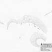
RCAHMS surveyed the standing stones at Broubster on 7 July 2005 with plane table and self-reducing alidade, producing a plan at a scale of 1:250.


