
Castledykes, Southern Annexe


Fort Annexe (Roman)
Site Name Castledykes, Southern Annexe
Classification Fort Annexe (Roman)
Canmore ID 79357
Site Number NS94SW 7.08
NGR NS 92850 44050
Datum OSGB36 - NGR
Permalink http://canmore.org.uk/site/79357


- Council South Lanarkshire
- Parish Carstairs
- Former Region Strathclyde
- Former District Clydesdale
- Former County Lanarkshire
NS94SW 7.08 928 440
Inspection of aerial photographs taken in 1984 suggests...another annexe may be defined by ditches linking the right bank of the Clyde to the southern defences of the fort.
(Information from Gordon Maxwell)
S S Frere 1988
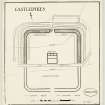
This annexe is part of the complex at Castledykes - see also NS94SW 7.00- 7.07, 7.09 and 16. NS94SW 7.00 and NS94SW 7.01 give air photograph references and a plan.
RCAHMS aerial survey in 1989 has confirmed the existence of an annexe to the S of the fort. Double ditches define an area at least 160m square within which streets and possible timber buildings can be seen.
S S Frere 1990
Aerial Photographic Transcription (29 July 1994)
An aerial transcription was produced from oblique aerial photographs. Information from Historic Environment Scotland (BM) 31 March 2017.

