
Creag Bhreac Mhor


Stone Row (Prehistoric)
Site Name Creag Bhreac Mhor
Classification Stone Row (Prehistoric)
Alternative Name(s) Upper Dounreay; Cnoc Freiceadain
Canmore ID 7898
Site Number ND06NW 8
NGR ND 0117 6595
Datum OSGB36 - NGR
Permalink http://canmore.org.uk/site/7898


- Council Highland
- Parish Reay
- Former Region Highland
- Former District Caithness
- Former County Caithness
ND06NW 8 0117 6596.
(ND 0117 6595) Standing Stones (NR)
OS 6"map, Caithness, 2nd ed., (1907)
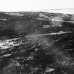
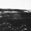
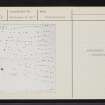
The thirteen rows of stones in this monument appear to radiate generally to the ESE from a group of four stones. These are arranged in an irregular square 4ft wide, and are between 1ft and 1ft 2ins long and the same in height above ground. The rows are about 100ft long and occupy an area some 44ft wide at the inner end and 115ft wide at the outer. The thin flat slabs which form the rows and which remain in situ appear to number 115 and are set on edge across the rows; they protrude about 1ft 6ins from the ground; the stones at the outer ends of the rows are larger. Some two thirds of the distance towards its broader extremity, the monument has been cut through by a road, and possibly a similar cause has destroyed the rows between the small square setting and their present commencement.
RCAHMS 1911.
The stones are said to mark the graves of those killed in the 'Sandside Chase' (ND06NW 4: 15th century clan battle).
Name Book 1871.
Only 56 stones, mostly set on edge, can be seen protruding through the heather to a maximum height of 0.6m. They are neither hewn nor marked and do not conform to any definite shape.
Resurveyed at 1:2500.
Visited by OS (N K B) 20 November 1964.
(ND 0117 6595) Stone Rows (NR)
OS 6"map, (1969)
The stone rows, in a hollow on undulating moorland, have been considerably obscured by peat and heather growth since the visit of the RCAHMS, and only about six rows (less than half of the stones planned by the RCAHMS) can be traced. The southern rows have been almost entirely buried by the vegetation. The stones appear to radiate from the direction of two cairns which are situated on a ridge to the NW (see ND06NW 14).
Revised at 1:2500.
Visited by OS (JB) 7 September 1969.

