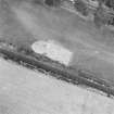
 |
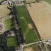
On-line Digital Images |
SC 1755056 |
RCAHMS Aerial Photography |
Oblique aerial view centred on the excavation of the pit-defined enclosure, taken from the WNW. |
24/8/1999 |
Item Level |
|
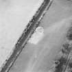 |
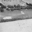
On-line Digital Images |
SC 1755057 |
RCAHMS Aerial Photography |
Oblique aerial view centred on the excavation of the pit-defined enclosure, taken from the ENE. |
24/8/1999 |
Item Level |
|
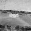 |
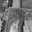
On-line Digital Images |
SC 1755058 |
RCAHMS Aerial Photography |
Oblique aerial view centred on the excavation of the pit-defined enclosure, taken from the NNE. |
24/8/1999 |
Item Level |
|
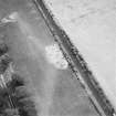 |
On-line Digital Images |
SC 1755059 |
RCAHMS Aerial Photography |
Oblique aerial view centred on the excavation of the pit-defined enclosure, taken from the NW. |
24/8/1999 |
Item Level |
|
 |
On-line Digital Images |
SC 1755060 |
RCAHMS Aerial Photography |
Oblique aerial view centred on the excavation of the pit-defined enclosure, taken from the S. |
24/8/1999 |
Item Level |
|
 |
On-line Digital Images |
SC 1755061 |
RCAHMS Aerial Photography |
Oblique aerial view centred on the excavation of the pit-defined enclosure, taken from the SW. |
24/8/1999 |
Item Level |
|
 |
On-line Digital Images |
SC 1755195 |
RCAHMS Aerial Photography |
Oblique aerial photograph of Parkneuk taken from the W, centred on the cropmarks of barrows and pits, with possible quarry pits of a Roman road and the line of a military road to the left and the Dunragit cropmark complex in the top right corner of the photograph. |
14/7/1997 |
Item Level |
|


