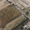
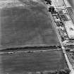
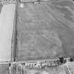
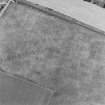
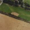
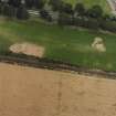
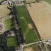
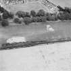
Accessibility

Font Size

100% 150% 200%

Background Colour

Default Contrast
Close Reset

Dunragit

Archaeological Landscape (Prehistoric)

Site Name Dunragit

Classification Archaeological Landscape (Prehistoric)

Canmore ID 78918

Site Number NX15NW 76

NGR NX 14924 57403

Datum OSGB36 - NGR

Permalink http://canmore.org.uk/site/78918

Ordnance Survey licence number AC0000807262. All rights reserved.
Canmore Disclaimer. © Bluesky International Limited 2025. Public Sector Viewing Terms

Toggle Aerial | View on large map

Digital Images

Oblique aerial view.
Oblique aerial view.Dunragit, oblique aerial view, taken from the NNE, showing an area defined as a cropmark complex.Oblique aerial view centred on the excavation of the pit-defined enclosure, taken from the ESE.Oblique aerial photograph of Parkneuk taken from the W, centred on the cropmarks of barrows and pits, with possible quarry pits of a Roman road and the line of a military road to the left and the Dunragit cropmark complex in the top right corner of the photograph.Oblique aerial view.Oblique aerial view.Oblique aerial view.Dunragit, oblique aerial view, taken from the NNE, showing an area defined as a cropmark complex.Oblique aerial view centred on the excavation of the pit-defined enclosure at Dunragit, taken from the S.Oblique aerial view centred on the cropmark complex, taken from the SE.Oblique aerial view.Oblique aerial photograph of Dunragit taken from the SSW, centred on a cropmark complex.Oblique aerial view centred on the excavation of the pit-defined enclosure, taken from the SW.Oblique aerial view centred on the excavation of the pit-defined enclosure, taken from the NE.Oblique aerial view centred on the excavation of the pit-defined enclosure at Dunragit, taken from the NW.Oblique aerial view.Oblique aerial view.Oblique aerial view.Oblique aerial view.Oblique aerial view.Oblique aerial photograph of Dunragit taken from the WNW, centred on a cropmark complex.Oblique aerial photograph of Dunragit taken from the SSE, centred on a cropmark complex.Oblique aerial view centred on the excavation of the pit-defined enclosure, taken from the S.Oblique aerial view centred on the excavation of the pit-defined enclosure, taken from the S.Oblique aerial view centred on the excavation of the pit-defined enclosure, taken from the NNE.Oblique aerial view centred on the cropmark complex, taken from the SE.Oblique aerial view.Oblique aerial view.Oblique aerial view centred on the excavation of the pit-defined enclosure, taken from the S.Oblique aerial view.Oblique aerial view.Oblique aerial photograph of Dunragit taken from the WSW, centred on a cropmark complex.Oblique aerial view centred on the excavation of the pit-defined enclosure, taken from the WNW.Oblique aerial view.Dunragit, oblique aerial view, taken from the SE, centred on an area defined as a cropmark complex. Cropmarks of a roman road and quarry pits are visible in the top right-hand corner of the photograph.Oblique aerial view centred on the excavation of the pit-defined enclosure, taken from the ENE.Oblique aerial view centred on the excavation of the pit-defined enclosure, taken from the NW.Oblique aerial view of the Dunragit bypass with Droughdool mound beyond, looking SSW.Oblique aerial view centred on the excavation of the pit-defined enclosure, taken from the SE.Oblique aerial view centred on the excavation of the pit-defined enclosure, taken from the E.Oblique aerial view centred on the excavation of the pit-defined enclosure, taken from the SW.

Administrative Areas

  • Council Dumfries And Galloway
  • Parish Old Luce
  • Former Region Dumfries And Galloway
  • Former District Wigtown
  • Former County Wigtownshire

Archaeology Notes

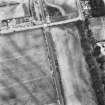
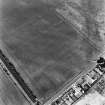
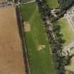
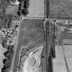
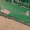
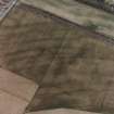
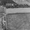
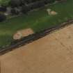
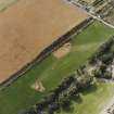
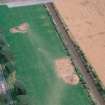
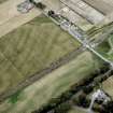
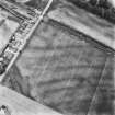
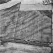
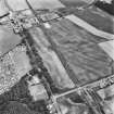
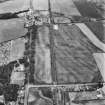
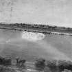
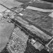
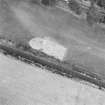
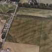
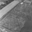
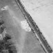
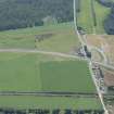
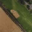
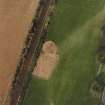
NX15NW 76.00 centred 149 573

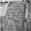
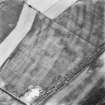
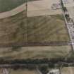
NX15NW 76.01 NX 1491 5739 Enclosure: pit-defined (pit-enclosure)

NX15NW 76.02 NX 1495 5723 Enclosure: pit-defined (possible)

NX15NW 76.03 NX 1482 5740 Ring-ditches

NX15NW 76.04 NX 1497 5745 Cursus: pit-defined; Pit-alignment

NX15NW 76.05 NX 1486 5752 Linear cropmark

See also NX15NE 69.00 Cropmark Complex and NX15NW 75.01 Roman Road.

Activities

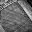
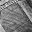
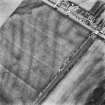
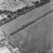
Aerial Photographic Transcription (10 September 1992 - 16 December 1992)

An aerial transcription was produced from oblique aerial photographs. Information from Historic Environment Scotland (BM) 31 March 2017.

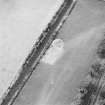
Note (11 April 2014)

Excavation revealed the postholes of concentric timber enclosures, and as such the classification has been changed from pit enclosures to timber enclosures.

Information from RCAHMS (KMM) 11 April 2014

References

MyCanmore Image Contributions


Contribute an Image

MyCanmore Text Contributions