 |
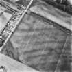
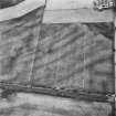
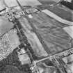
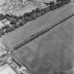
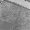
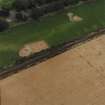
On-line Digital Images |
SC 1754884 |
RCAHMS Aerial Photography |
Oblique aerial view. |
1992 |
Item Level |
|
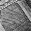 |
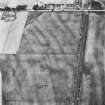
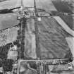
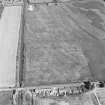
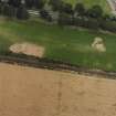
On-line Digital Images |
SC 1754885 |
RCAHMS Aerial Photography |
Oblique aerial view centred on the cropmark complex, taken from the SE. |
1992 |
Item Level |
|
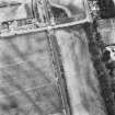 |
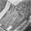
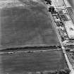
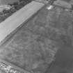
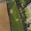
On-line Digital Images |
SC 1754886 |
RCAHMS Aerial Photography |
Oblique aerial view. |
1992 |
Item Level |
|
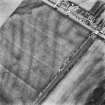 |
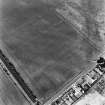
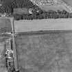
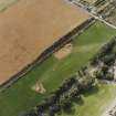
On-line Digital Images |
SC 1754887 |
RCAHMS Aerial Photography |
Oblique aerial view. |
1992 |
Item Level |
|
 |
On-line Digital Images |
SC 1754888 |
RCAHMS Aerial Photography |
Oblique aerial view. |
1992 |
Item Level |
|
 |
On-line Digital Images |
SC 1754892 |
RCAHMS Aerial Photography |
Oblique aerial view. |
1992 |
Item Level |
|
 |
On-line Digital Images |
SC 1754893 |
RCAHMS Aerial Photography |
Oblique aerial view. |
1992 |
Item Level |
|
 |
On-line Digital Images |
SC 1754894 |
RCAHMS Aerial Photography |
Oblique aerial view. |
1992 |
Item Level |
|
 |
On-line Digital Images |
SC 1754895 |
RCAHMS Aerial Photography |
Oblique aerial view. |
1992 |
Item Level |
|
 |
On-line Digital Images |
SC 1754896 |
RCAHMS Aerial Photography |
Oblique aerial view. |
1992 |
Item Level |
|
 |
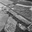
On-line Digital Images |
SC 1755010 |
RCAHMS Aerial Photography |
Dunragit, oblique aerial view, taken from the NNE, showing an area defined as a cropmark complex. |
29/3/1995 |
Item Level |
|
 |
On-line Digital Images |
SC 1755011 |
RCAHMS Aerial Photography |
Dunragit, oblique aerial view, taken from the NNE, showing an area defined as a cropmark complex. |
29/3/1995 |
Item Level |
|
 |
On-line Digital Images |
SC 1755012 |
RCAHMS Aerial Photography |
Dunragit, oblique aerial view, taken from the SE, centred on an area defined as a cropmark complex. Cropmarks of a roman road and quarry pits are visible in the top right-hand corner of the photograph. |
29/3/1995 |
Item Level |
|
 |
On-line Digital Images |
SC 1755035 |
RCAHMS Aerial Photography |
Oblique aerial photograph of Dunragit taken from the WNW, centred on a cropmark complex. |
14/7/1997 |
Item Level |
|
 |
On-line Digital Images |
SC 1755036 |
RCAHMS Aerial Photography |
Oblique aerial photograph of Dunragit taken from the WSW, centred on a cropmark complex. |
14/7/1997 |
Item Level |
|
 |
On-line Digital Images |
SC 1755037 |
RCAHMS Aerial Photography |
Oblique aerial photograph of Dunragit taken from the SSW, centred on a cropmark complex. |
14/7/1997 |
Item Level |
|
 |
On-line Digital Images |
SC 1755038 |
RCAHMS Aerial Photography |
Oblique aerial photograph of Dunragit taken from the SSE, centred on a cropmark complex. |
14/7/1997 |
Item Level |
|
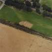 |
On-line Digital Images |
SC 1755049 |
RCAHMS Aerial Photography |
Oblique aerial view centred on the excavation of the pit-defined enclosure, taken from the S. |
24/8/1999 |
Item Level |
|
 |
On-line Digital Images |
SC 1755050 |
RCAHMS Aerial Photography |
Oblique aerial view centred on the excavation of the pit-defined enclosure, taken from the SE. |
24/8/1999 |
Item Level |
|
 |
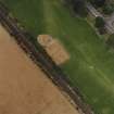
On-line Digital Images |
SC 1755051 |
RCAHMS Aerial Photography |
Oblique aerial view centred on the excavation of the pit-defined enclosure, taken from the E. |
24/8/1999 |
Item Level |
|
 |
On-line Digital Images |
SC 1755052 |
RCAHMS Aerial Photography |
Oblique aerial view centred on the excavation of the pit-defined enclosure, taken from the SW. |
24/8/1999 |
Item Level |
|
 |
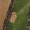
On-line Digital Images |
SC 1755053 |
RCAHMS Aerial Photography |
Oblique aerial view centred on the excavation of the pit-defined enclosure, taken from the S. |
24/8/1999 |
Item Level |
|
 |
On-line Digital Images |
SC 1755054 |
RCAHMS Aerial Photography |
Oblique aerial view centred on the excavation of the pit-defined enclosure, taken from the ESE. |
24/8/1999 |
Item Level |
|
 |
On-line Digital Images |
SC 1755055 |
RCAHMS Aerial Photography |
Oblique aerial view centred on the excavation of the pit-defined enclosure, taken from the NE. |
24/8/1999 |
Item Level |
|


