Accessibility

Font Size

100% 150% 200%

Background Colour

Default Contrast
Close Reset

Dalton, Old Parish Church

Burial Ground (Medieval), Church (Medieval)

Site Name Dalton, Old Parish Church

Classification Burial Ground (Medieval), Church (Medieval)

Alternative Name(s) Mickle Dalton; Dalton Magna; Meikle Dalton

Canmore ID 78911

Site Number NY17SW 1

NGR NY 11430 73979

Datum OSGB36 - NGR

Permalink http://canmore.org.uk/site/78911

Ordnance Survey licence number AC0000807262. All rights reserved.
Canmore Disclaimer. © Bluesky International Limited 2025. Public Sector Viewing Terms

Toggle Aerial | View on large map

Digital Images

General view from W.
General view from W.Interior view, detail of the inscription on the east gravestone within Dalton Old Parish ChurchOblique aerial view of Dalton Old Parish Church, taken from the NNE.Oblique aerial view of Dalton Old Parish Church, taken from the N.Oblique aerial view.Dalton, Old Parish Church, NY17SW 1, Ordnance Survey index card, page number 1, RectoDalton, Old Parish Church, NY17SW 1, Ordnance Survey index card, RectoView of gable and external stair.View across graveyard to Dalton Old Parish Church, taken from SSWView of W elevation of Dalton Old Parish ChurchInterior view, looking west across the burial plots within Dalton Old Parish ChurchView of S and E elevations of Dalton Old Parish Church, taken from the SEView looking NE across graveyard of Dalton Old Parish Church, showing the ruinous 18th century church in relation to its late-19th century successorView looking E across graveyard to the W gabled elevation of Dalton Old Parish ChurchOblique aerial view of Dalton Old Parish Church, taken from the NW.Oblique aerial view.View from W.Interior view, looking east across burial plots within Dalton Old Parish ChurchView of the gabled E elevation of Dalton Old Parish ChurchView looking W from road into Dalton, showing Dalton Parish, with ruinous Dalton Old Parish Church beyondOblique aerial view.Oblique aerial view.Detail of eaves and squareheaded window.View of gable and external stair.View along N elevation of Dalton Old Parish Church, taken from WNWView of E and N elevations of Dalton Old Parish Church, taken from NEInterior view, detail of the burial plots located within Dalton Old Parish ChurchDetail of gravestone situated immediately adjacent to SE corner of Dalton Old Parish ChurchDetail of blocked doorway with window above at E end of N elevation at Dalton Old Parish ChurchPlanOblique aerial view of Dalton Old Parish Church, taken from the SE.Oblique aerial view.Dalton, oblique aerial view, taken from the ENE, centred on the old parish church and the parish church.  A road bridge is visible in the centre top half of the photograph.Dalton, oblique aerial view, taken from the SE, centred on the old parish church and the parish church. A road bridge is visible in the centre left-hand side of the photograph.View of S elevation of Dalton Old Parish ChurchDetail of former doorway, sub-divided with stone insertion to centre, at E end of the S elevation of Dalton Old Parish ChurchDetail of birdcage bellcote at apex of W gable at Dalton Old Parish ChurchOblique aerial view of Dalton Old Parish Church, taken from the E.Oblique aerial view.Dalton, oblique aerial view, taken from the NE, centred on the old parish church and the parish church.  A road bridge is visible in the top right hand corner of the photograph.Dalton, oblique aerial view, taken from the ESE, centred on the old parish church and the parish church.  A road bridge is visible in the top left hand corner of the photograph.Detail of eaves.General view from NE.View of S and W elevations of Dalton Old Parish Church from SWView along N elevation of Dalton Old Parish Church, taken from ENEOblique aerial view of Dalton Old Parish Church, taken from the NE.Map showing the distribution of medieval parish churches (named) in Annandale and Eskdale, against the pattern of parish boundaries at the present day. Published in Eastern Dumfriesshire: an archaeological landscape.View of N and E elevations of Dalton Old Parish Church, taken from NNEDetail of the loft staircase on the east elevation of Dalton Old Parish ChurchView looking along the S elevation of Dalton Old Parish Church, taken from the WSWDetail of window aperture to centre of S elevation of Dalton Old Parish ChurchDetail of loft entrance and bullseye window to upper gable of E elevation at Dalton Old Parish ChurchView of Dalton Parish Church from WSW, showing S and W elevationsView looking E across graveyard, showing the ruinous Dalton Old Parish Church in relation to the present Dalton Parish ChurchOblique aerial view.Photographs and research notes relating to graveyard monuments in Dalton Churchyard, Dumfries.General view from NE.Detail of gable, bellcote and windvane.Detail of gable, bellcote, windvane and squareheaded windows.Interior view, looking west within Dalton Old Parish ChurchInterior view, looking east within Dalton Old Parish ChurchInterior view, detail of the inscription on the west gravestone within Dalton Old Parish ChurchDetail of classical memorial (inscriptions illegible) set into the S elevation of Dalton Old Parish ChurchView of Dalton Parish Church from WNW, showing N elevation and belltowerDalton, oblique aerial view, taken from the ENE, centred on the old parish church and the parish church.  A road bridge is visible in the centre top half of the photograph.Dalton, oblique aerial view, taken from the SE, centred on the old parish church and the parish church.  A road bridge is visible in the centre left half of the photograph.Dalton, oblique aerial view, taken from the SE, centred on the old parish church and the parish church.  A road bridge is visible in the centre left hand side of the photograph.Dalton, oblique aerial view, taken from the SSW, centred on the old parish church and the parish church.  A road bridge is visible in the bottom left hand corner of the photograph.Photographs and research notes relating to graveyard monuments in Dalton Churchyard, Dumfries.Dalton, Old Parish Church, NY17SW 1, Ordnance Survey index card, page number 2, VersoDalton, Old Parish Church, NY17SW 1, Ordnance Survey index card, Recto

Administrative Areas

  • Council Dumfries And Galloway
  • Parish Dalton
  • Former Region Dumfries And Galloway
  • Former District Annandale And Eskdale
  • Former County Dumfries-shire

Archaeology Notes

NY17SW 1 11430 73979

(NY 1142 7397) Church (NR) (remains of).

OS 1:10000 map (1973)

For present parish church (NY 1138 7399), see NY17SW 33. For Little Dalton Church (NY 0891 7468), see NY07SE 11.

Meikle and Little Dalton were first united by Parliament in 1609 but Little Dalton was joined to Mouswald by letter of James VI to the Privy Council, 27 May 1615. It was again united to Meikle Dalton on 28 June 1633.

H Scott 1915-61.

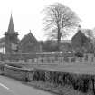
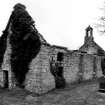
Dalton Old Parish Church (Mickle Dalton) was erected in 1704. It is oblong on plan, measuring 53ft 3 ins by 20ft 4 ins internally. Its N side and E and W ends are built on the base of the walls of a previous church. This is shown by a massive plinth or base-course which extends all along the N side of the church, except where it has been cut through for doorways. On the lower part of the W wall several courses of masonry of much earlier date than the rest of the church are visible above it. These remains of an earlier church may date from the 13th century. Now roofless, this building was superseded by the present church, which was built in 1895 (at NY 1138 7399).

RCAHMS 1920, visited 1912; Third Statistical Account (TSA) 1862 (C H B Harkness).

Dalton Magna (Glasgow, Annandale). A parsonage in Bagimond, the church, also known as Meikle Dalton, remained unappropriated, its patronage passing in 1552 from Gilbert Grierson of Dalton to Lindsay of Barcloy.

I B Cowan 1967.

The walls of this church (1.2m thick) still stand to roof height and are generally in a fair state of preservation. No information was obtained regarding the earlier church, nor could a dedication be obtained.

Visited by OS (WDJ) 27 October 1967.

No change to previous field report.

Visited by OS (JP) 21 February 1973.

To the SE [of the present parish church, NY17SW 33], the roofless shell of the Old Parish Church that was built in 1704, its N, E and W walls incorporating the bottom courses of the stonework of its medieval predecessor. Rubble-built rectangle with surprisingly smart detail. Square-headed windows and doors, their surrounds embellished with V-jointed rustication. In the long N wall, two tall windows flanked by doors which have been converted to windows. At each gable, a forestair to a gallery door; over the E door, a bullseye window. The gables' ground=floor doors are insertions, perhaps of the early 19th cent. On the W gable, a birdcage bellcote topped by a weathercock; chimney on the E gable. The interior has had a gallery around three sides.

Just NW of the Old Parish Church, a late Georgian burial enclosure. Round-arched entrance and rusticated angle quoins. S of the Parish Church, 18th century headstones, two carved with pilasters and reminders of death, a third omitting the pilasters but multiplying the grisly emblems in compensation. To the W, the suave classical monument to the Carruthers of Whitecroft, probably of the late 18th century; tall plinth carrying an urn-finialled obelisk.

J Gifford 1996.

Activities

Field Visit (25 August 1993)

NY17SW 1 1143 7397

Nothing is visible of the medieval parish church of Dalton which probably occupied much the same site as its successor (NY17SW 33) and was situated to take advantage of a large knoll in rolling terrain.

Visited by RCAHMS (IMS, PC), 25 August 1993.

Listed as church and burial-ground.

RCAHMS 1997.

Archaeological Evaluation (28 October 2013 - 1 November 2013)

NY 11420 73980 A trial trenching evaluation was undertaken, 28 October – 1 November 2013, in advance of the dismantling and reinstatement of a wall. The excavation of three 1m2 trenches, adjacent to the N wall of the churchyard, recorded late medieval dumping deposits, on of which contained disarticulated human remains. A single 19th-century inhumation was also recorded.

Archive: Dumfries and Galloway Council HER and RCAHMS. Report: ADS

Andrew Nicholson, 2013

(Source: DES)

References

MyCanmore Image Contributions


Contribute an Image

MyCanmore Text Contributions