
Following the launch of trove.scot in February 2025 we are now planning the retiral of some of our webservices. Canmore will be switched off on 24th June 2025. Information about the closure can be found on the HES website: Retiral of HES web services | Historic Environment Scotland
Dalswinton, Bankhead


Field Boundary (Period Unassigned)(Possible)
Site Name Dalswinton, Bankhead
Classification Field Boundary (Period Unassigned)(Possible)
Canmore ID 78755
Site Number NX98SW 84
NGR NX 93081 84517
Datum OSGB36 - NGR
Permalink http://canmore.org.uk/site/78755


- Council Dumfries And Galloway
- Parish Kirkmahoe
- Former Region Dumfries And Galloway
- Former District Nithsdale
- Former County Dumfries-shire
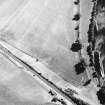
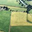
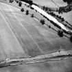
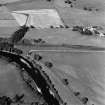
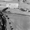
NX98SW 84 9309 8463.
What may be a field boundary has been recorded as cropmarks on oblique aerial photography (RCAHMSAP 1997).
Information from RCAHMS (BN) 29 April 2008
Aerial Photographic Transcription (9 May 2012)

