
Following the launch of trove.scot in February 2025 we are now planning the retiral of some of our webservices. Canmore will be switched off on 24th June 2025. Information about the closure can be found on the HES website: Retiral of HES web services | Historic Environment Scotland
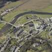
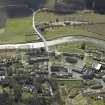
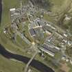
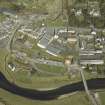
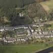
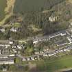
Walkerburn


Village (Period Unassigned)
Site Name Walkerburn
Classification Village (Period Unassigned)
Canmore ID 78728
Site Number NT33NE 31
NGR NT 36144 37122
NGR Description Centred NT 36144 37122
Datum OSGB36 - NGR
Permalink http://canmore.org.uk/site/78728


- Council Scottish Borders, The
- Parish Innerleithen
- Former Region Borders
- Former District Tweeddale
- Former County Peebles-shire
NMRS REFERENCE
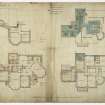
House at Wlalkerburn
Architect: Pilkington & Bell
Sbc Note
Visibility: This is an upstanding building.
Information from Scottish Borders Council.

