
Pricing Change
New pricing for orders of material from this site will come into place shortly. Charges for supply of digital images, digitisation on demand, prints and licensing will be altered.
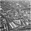
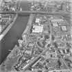
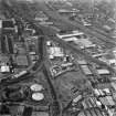
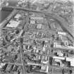
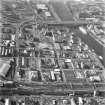
Glasgow, Kingston


General View (Period Unassigned)
Site Name Glasgow, Kingston
Classification General View (Period Unassigned)
Canmore ID 78562
Site Number NS56SE 356
NGR NS 57 64
Datum OSGB36 - NGR
Permalink http://canmore.org.uk/site/78562


- Council Glasgow, City Of
- Parish Govan (City Of Glasgow)
- Former Region Strathclyde
- Former District City Of Glasgow
- Former County Lanarkshire
KINGSTON
Shipbuilding moved down river as Glasgow Harbour developed. Kingston Dock opened behind Windmillcroft Quay in 1867, but was too small to attract a railway connection. Filled in during the early 1960s, it is now the site of the south end of the Kingston Bridge. In the first half of the 19th century, manufacturing and then warehousing dominated the area after the Scottish Co-operative Wholesale Society (SCWS) built their huge empire south of Kingston Dock from 1872.
Taken from "Greater Glasgow: An Illustrated Architectural Guide", by Sam Small, 2008. Published by the Rutland Press http://www.rias.org.uk


