
Rain Sike


Cultivation Remains (Period Unassigned)
Site Name Rain Sike
Classification Cultivation Remains (Period Unassigned)
Canmore ID 78506
Site Number NY38SW 61
NGR NY 312 843
Datum OSGB36 - NGR
Permalink http://canmore.org.uk/site/78506


- Council Dumfries And Galloway
- Parish Langholm
- Former Region Dumfries And Galloway
- Former District Annandale And Eskdale
- Former County Dumfries-shire
Desk Based Assessment (March 2014 - March 2015)
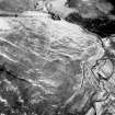
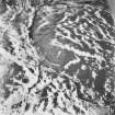
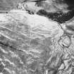
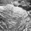
Rig and furrow remains are visible on oblique aerial photographs from 1998 spread over an area approximately 500m by 250m south of Arresgill Farm. A field survey undertaken by CFA in 2007 did not find any remains of cultivation terraces, but remains of rig and furrow cultivation, aligned east to west, 2m wide by 0.3m high, was identified across an area approximately 250m by 150m. The area of rig and furrow cultivation was not recommended for preservation in 2008 forestry planting scheme.
information from Héléna Gray, (CFA Archaeology Ltd), August 2015
OASIS ID: cfaarcha1-278420
Project (29 May 2014)
An archaeological evaluation was undertaken by CFA Archaeology Ltd, a desk based assessment and walk over survey (May 29th 2014) was conducted
The historic environment record within the Site Boundary is relatively limited, although there is some potential for the proposed development site to contain previously unknown heritage assets from at least the later prehistoric period onwards, given the historic landscape character of the wider area. Taking this into account, the archaeological potential of the proposed development site is considered to be low.
A summary assessment, on a site by site basis, of the predicted effects on the settings of assets within a 10km radius where the blade tip ZTV indicates that there would be theoretical views of one or more turbines
information from Héléna Gray, (CFA Archaeology Ltd), August 2015
OASIS ID: cfaarcha1-278420

