
Pricing Change
New pricing for orders of material from this site will come into place shortly. Charges for supply of digital images, digitisation on demand, prints and licensing will be altered.
Tulloch Of Stemster


Broch (Iron Age)(Possible)
Site Name Tulloch Of Stemster
Classification Broch (Iron Age)(Possible)
Canmore ID 7834
Site Number ND06NW 13
NGR ND 0399 6548
Datum OSGB36 - NGR
Permalink http://canmore.org.uk/site/7834


- Council Highland
- Parish Reay
- Former Region Highland
- Former District Caithness
- Former County Caithness
ND06NW 13 0399 6548
(ND 0399 6548) Tulloch of Stemster (NR)
OS 6" map, Caithness, 2nd ed., (1907)
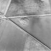
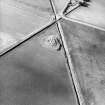
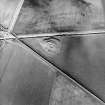
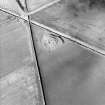
The broch, Tulloch of Stemster, is now a mound about 5ft high and 70ft in diameter. Over the top are a number of circular hollows, from 2 to 3ft in depth and from 10 to 15ft in diameter, apparently secondary constructions. The broch stands on a knoll steeply scarped to a height of 8ft and probably revetted; a built face is exposed at the base on the NNW, and there is a parapet around the edge of the knoll.
RCAHMS 1911.
As described above.
Resurveyed at 1:2500.
Visited by OS (N K B), 4 November 1964.
(ND 0399 6548) Tulloch of Stemster (NAT)
Broch (NR) (remains of)
OS 6" map, (1969)
Tulloch of Stemster (name verified), a turf-covered broch mound on a steeply scarped knoll, is generally as described by the RCAHMS. There is no trace of any wall faces, and the 'crust' of the mound, where the turf has eroded, is of earth and small stones with little or no trace of substantial building stone. The five depressions in the mound are almost certainly the result of surface quarrying.
The farmer at Stemster can recall as a child a lintelled passage, about 1.0 to 1.5m wide, which extended some distance into the mound, but this is now filled in leaving no trace.
Visited by OS (N K B), 24 November 1981.
Publication Account (2007)
ND06 12 TULLOCH OF LYBSTER ND/0268 6947
Probable broch in Thurso, Caithness, which has been cleared out at some time, and a wide gap made in the wall on the south-east and north-west. Small parts of the inner face were visible in 1910 [2], giving an internal diameter of 9.91m (32ft 6in) and a wall thickness of some 4.42m (14ft 6in); the overall diameter would therefore be about 18.76m (61ft 6in). Traces of the outer face are also visible [1]. The broch is surrounded by a wide ditch and part of a surrounding wall beyond this is on the west; this wallface was not visible in 1981 [3].
Sources: 1. NMRS site no. ND 06 NW 20: 2. RCAHMS 1911a, 83, no. 346: 3. Mercer 1981, 140, no. 337.
E W MacKie 2007

