
Pricing Change
New pricing for orders of material from this site will come into place shortly. Charges for supply of digital images, digitisation on demand, prints and licensing will be altered.
Upcoming Maintenance
Please be advised that this website will undergo scheduled maintenance on the following dates:
Thursday, 9 January: 11:00 AM - 3:00 PM
Thursday, 23 January: 11:00 AM - 3:00 PM
Thursday, 30 January: 11:00 AM - 3:00 PM
During these times, some functionality such as image purchasing may be temporarily unavailable. We apologise for any inconvenience this may cause.
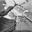
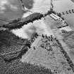
Nether Pittendriech


Rig And Furrow (Medieval) - (Post Medieval), Track(S) (Period Unassigned)
Site Name Nether Pittendriech
Classification Rig And Furrow (Medieval) - (Post Medieval), Track(S) (Period Unassigned)
Canmore ID 78184
Site Number NO14SE 92
NGR NO 15182 41177
Datum OSGB36 - NGR
Permalink http://canmore.org.uk/site/78184


- Council Perth And Kinross
- Parish Lethendy
- Former Region Tayside
- Former District Perth And Kinross
- Former County Perthshire
NO14SE 92 NO 15182 41177
Aerial photographs taken in 1984 by C Martin, St Andrews University (84.17.9-13).
(Undated) information in NMRS.
The line of a hollow trackway has been recorded as a cropmark on oblique aerial photographs (RCAHMSAP 1998), to the W of Nether Pittendriech. Less marked cropmarks in the same field record the presence of rig.
Information from RCAHMS (KMM) 7 January 2004.

