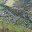
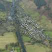
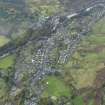
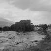
Accessibility

Font Size

100% 150% 200%

Background Colour

Default Contrast
Close Reset

Killin, General

Burgh (Medieval), Village (Period Unassigned)

Site Name Killin, General

Classification Burgh (Medieval), Village (Period Unassigned)

Alternative Name(s) Falls Of Dochart; River Dochart; Loch Tay

Canmore ID 78139

Site Number NN53SE 37

NGR NN 57315 33073

NGR Description Centred NN 57315 33073

Datum OSGB36 - NGR

Permalink http://canmore.org.uk/site/78139

Ordnance Survey licence number AC0000807262. All rights reserved.
Canmore Disclaimer. © Bluesky International Limited 2025. Public Sector Viewing Terms

Toggle Aerial | View on large map

Digital Images

General view of Killin.
Titled: 'On the Dochart at Killin. No. 1013 G.W.W.'
PHOTOGRAPH ALBUM No.33: COURTAULD ALBUM.
General view of Killin.
Titled: 'On the Dochart at Killin. No. 1013 G.W.W.'
PHOTOGRAPH ALBUM No.33: COURTAULD ALBUM.General oblique aerial view centred on the village, taken from the NNW.Harry Sutton Palmer. 'Killin, Perthshire'. Watercolour.Oblique aerial view centred on Loch Tay with Killin village adjacent, taken from the SW.General oblique aerial view centred on the village, taken from the NE.General oblique aerial view centred on the village, taken from the N.General view from SW, along Dochart Road and Gray StreetGeneral oblique aerial view of Glen Dochart under snow with Killin and Loch Tay in the distance, looking ENE.Oblique aerial view centred on Loch Tay with Killin village adjacent, taken from the SW.General oblique aerial view centred on the village with Loch Tay adjacent, taken from the SW.General oblique aerial view of Glen Dochart under snow with Killin and Loch Tay in the distance, looking ENE.Oblique aerial view.Distant view of landscape from Lix Estate.General oblique aerial view centred on the village with Loch Tay beyond, taken from the SW.Oblique aerial view of the village centred on the road bridge, taken from the NE.View of croft lands leading down to Lochtay, taken from Kenmore Glebe, Kenmore, Argyll.
Titled:  '180. On Lochtay from Kenmore Glebes'.
PHOTOGRAPH ALBUM NO 186: J B MACKENZIE ALBUM'Old garden at Pinkie burn'.

View of river Dochart and cottages on Gray Street, Killin, from SW.Distant view of landscape from Lix Estate.

Administrative Areas

  • Council Stirling
  • Parish Killin
  • Former Region Central
  • Former District Stirling
  • Former County Perthshire

Archaeology Notes

NN53SE 37 centred 57315 33073

For Bridge of Dochart (NN 5713 3250), see NN53SE 51.

Erected burgh of barony 1694.

G S Pryde 1965.

Architecture Notes

NMRS REFERENCE:

Killin Parish (traced from unfinished plans by Ordnance Survey)

PLANS:

Dick Peddie & MacKay, Edinburgh

Bin 12, Bag 1 n.s. n.d.

EXTERNAL REFERENCE:

Killin, Monument

SCOTTISH RECORD OFFICE

GD 112/5 Vouchers of Factors Accounts 1643 - 1797

476/35 Due to Alexander Laing, Edinburgh for drawings plans of a monument, gates, parapets and railings, 1797

References

MyCanmore Image Contributions


Contribute an Image

MyCanmore Text Contributions