
Pricing Change
New pricing for orders of material from this site will come into place shortly. Charges for supply of digital images, digitisation on demand, prints and licensing will be altered.
Wester Shenalt


Building(S) (Period Unassigned), Field System (Period Unassigned)
Site Name Wester Shenalt
Classification Building(S) (Period Unassigned), Field System (Period Unassigned)
Alternative Name(s) Glen Gairn
Canmore ID 78081
Site Number NJ20SW 2
NGR NJ 209 019
Datum OSGB36 - NGR
Permalink http://canmore.org.uk/site/78081

- Council Aberdeenshire
- Parish Crathie And Braemar
- Former Region Grampian
- Former District Kincardine And Deeside
- Former County Aberdeenshire
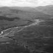
The remains of a farmstead and field-system are situated approximately 150m north of the River Gairn, west of the Wester Shenalt Burn.
The farmstead comprises five unroofed structures, lying in an area of enclosed fields. It may have been occupied until the early years of the twentieth century, as one building is shown as roofed on the 2nd edition of the Ordnance Survey 6-inch map.
Text prepared by RCAHMS as part of the Accessing Scotland's Past project
NJ20SW 2 209 019
(Location cited as NJ 209 019). Wester Shenalt, Glen Gairn. The remains of five longhouses have been recorded scattered along the foot of a gentle SE-facing slope in an area of rough grazing at an altitude of 457m OD.
NMRS, MS/712/3.
Three unroofed buildings, one roofed building and a field-system are depicted on the 1st edition of the OS 6-inch map (Aberdeenshire 1869, sheet lxxix). Five unroofed buildings and the field-system are shown on the current edition of the OS 1:10000 map (1971).
Information from RCAHMS (SAH) 15 April 1999.

