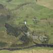
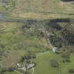
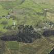
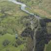
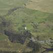
Accessibility

Font Size

100% 150% 200%

Background Colour

Default Contrast
Close Reset

Glenhoul

Farmstead (Period Unassigned)

Site Name Glenhoul

Classification Farmstead (Period Unassigned)

Canmore ID 77954

Site Number NX68NW 18.02

NGR NX 6091 8788

Datum OSGB36 - NGR

Permalink http://canmore.org.uk/site/77954

Ordnance Survey licence number AC0000807262. All rights reserved.
Canmore Disclaimer. © Bluesky International Limited 2025. Public Sector Viewing Terms

Toggle Aerial | View on large map

Digital Images

Oblique aerial view centred on the power station, taken from the SSW.
Oblique aerial view centred on the power station, taken from the SSW.View of former cottage.Oblique aerial view centred on the power station with the surge tower in the foreground, taken from the NE.View of entrance from S.Oblique aerial view centred on the power station, taken from the NW.View of entrance from SE.Oblique aerial view centred on the power station with the surge tower in the foreground, taken from the NNE.Oblique aerial view centred on Kendoon power station, taken from the SE.

Administrative Areas

  • Council Dumfries And Galloway
  • Parish Dalry (Stewartry)
  • Former Region Dumfries And Galloway
  • Former District Stewartry
  • Former County Kirkcudbrightshire

Activities

Note

A farmstead, comprising three roofed buildings, one partially roofed, one unroofed building and one enclosure is depicted on the 1st edition of the OS 6-inch map (Kirkcudbrightshire 1853, sheet 9). A courtyard farmstead of five roofed buildings and four enclosures is shown on the current edition of the OS 1:10000 map (1981).

Information from RCAHMS (AKK) 13 September 1999.

References

MyCanmore Image Contributions


Contribute an Image

MyCanmore Text Contributions