
Pricing Change
New pricing for orders of material from this site will come into place shortly. Charges for supply of digital images, digitisation on demand, prints and licensing will be altered.
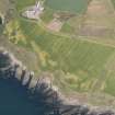
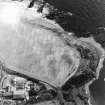
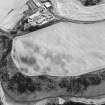
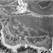
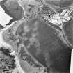
Inverbervie, Kinghornie


Farmstead (Period Unassigned), House (Period Unassigned)
Site Name Inverbervie, Kinghornie
Classification Farmstead (Period Unassigned), House (Period Unassigned)
Canmore ID 77764
Site Number NO87SW 57
NGR NO 836 727
Datum OSGB36 - NGR
Permalink http://canmore.org.uk/site/77764


- Council Aberdeenshire
- Parish Kinneff
- Former Region Grampian
- Former District Kincardine And Deeside
- Former County Kincardineshire

