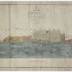
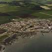
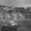
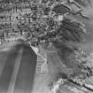
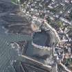
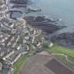
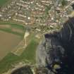
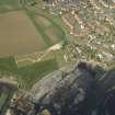
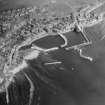
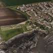
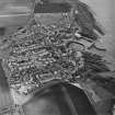
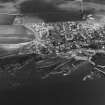
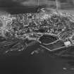
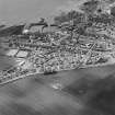
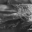
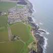
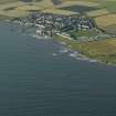
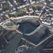
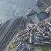
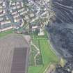
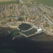
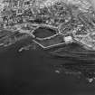
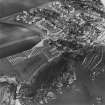
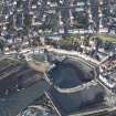
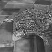
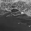
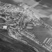
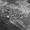
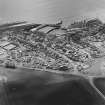
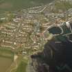
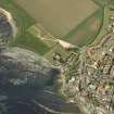
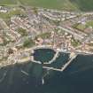
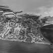
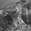
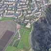
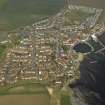
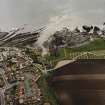
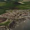
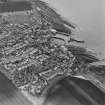
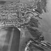
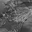
Accessibility

Font Size

100% 150% 200%

Background Colour

Default Contrast
Close Reset

St Monance

Burgh (Medieval), Village (Period Unassigned)

Site Name St Monance

Classification Burgh (Medieval), Village (Period Unassigned)

Alternative Name(s) St Monans; St Monan's; St Minnan's

Canmore ID 77553

Site Number NO50SW 86

NGR NO 5255 0165

NGR Description Centred NO 5255 0165

Datum OSGB36 - NGR

Permalink http://canmore.org.uk/site/77553

Ordnance Survey licence number AC0000807262. All rights reserved.
Canmore Disclaimer. © Bluesky International Limited 2025. Public Sector Viewing Terms

Toggle Aerial | View on large map

Digital Images

Map of St Monance Harbour.
Map of St Monance Harbour.General oblique aerial view of Newark Castle with St Monance in the background, taken from the W.Oblique aerial view of St Monance centred on the village, church and harbour, taken from the S.Oblique aerial view of St Monance centred on the village, harbour, church and burial ground, taken from the NW.Oblique aerial view of St Monance centred on the village, harbour, church and burial ground, taken from the SW.Oblique aerial view.Oblique aerial viewOblique aerial viewOblique aerial view centred on the church, churchyard and burial ground, taken from the SSW.Oblique aerial view centred on the church, churchyard and burial ground, taken from the SSE.General View St Monance, Fife, Scotland. Oblique aerial photograph taken facing North/East. Oblique aerial view of St Monance centred on the church and village, taken from the SSE.Oblique aerial view of St Monance centred on the village, harbour, church and burial ground, taken from the WSW.Oblique aerial view of St Monance centred on the village, harbour, church and burial ground, taken from the SE.Oblique aerial view of St Monance centred on the village and harbour, taken from the SE.Oblique aerial view of St Monance centred on the village, harbour, church and burial ground, taken from the NNE.Oblique aerial view of St Monance centred on the village, church and burial ground, taken from the SE.Oblique aerial view of St Monance centred on the village, church and burial ground, taken from the ESE.Oblique aerial view.General oblique aerial view centred on the village, taken from the ESE.General oblique aerial view of Newark Castle with St Monance in the background, taken from the W.Oblique aerial view of St Monance centred on the village, church and burial ground, taken from the ENE.Oblique aerial view.Oblique aerial viewOblique aerial viewOblique aerial viewOblique aerial viewOblique aerial view of the village centred on the harbour, taken from the SE.Oblique aerial view of St Monance centred on the village and harbour, taken from the ESE.Oblique aerial view of St Monance centred on the village, church and burial ground, taken from the S.Oblique aerial viewGeneral viewOblique aerial view of St Monance centred on the village, harbour, church and burial ground, taken from the SW.Oblique aerial view of St Monance centred on the village and harbour, taken from the ESE.Oblique aerial view of St Monance centred on the village and harbour, taken from the ESE.Oblique aerial view of St Monance centred on the village and harbour, taken from the ESE.Oblique aerial view of St Monance centred on the village and harbour, taken from the NNW.Oblique aerial view of St Monance centred on the village, church and burial ground, taken from the NNE.General viewGeneral oblique aerial view of the village centred on the harbour with the church and the burial-ground adjacent, taken from the SSW.Oblique aerial view centred on the church, churchyard and burial ground, taken from the E.General oblique aerial view of St Monans centred on the harbours, taken from the SSE.General View St Monance, Fife, Scotland. Oblique aerial photograph taken facing North/West. This image was marked by AeroPictorial Ltd for photo editing.Oblique aerial view of St Monance centred on the village, harbour, church and burial ground, taken from the NW.Oblique aerial view of St Monance centred on the village, church and burial ground, taken from the NE.Oblique aerial viewGeneral oblique aerial view of the village centred on the harbour with the church and the burial-ground adjacent, taken from the SW.Oblique aerial view centred on the church, churchyard and burial ground, taken from the NE.Oblique aerial view of St Monance centred on the church with the village adjacent, taken from the NNW.Oblique aerial view of St Monance centred on the church and village, taken from the SSW.Oblique aerial view of St Monance centred on the church and village, taken from the ESE.Oblique aerial view of St Monance centred on the village, church and harbour, taken from the SSW.Oblique aerial view of St Monance centred on the village, harbour, church and burial ground, taken from the E.Oblique aerial view of St Monance centred on the village, harbour, church and burial ground, taken from the WSW.Oblique aerial view of St Monance centred on the village, harbour, church and burial ground, taken from the NE.

Administrative Areas

  • Council Fife
  • Parish St Monance
  • Former Region Fife
  • Former District North East Fife
  • Former County Fife

Archaeology Notes

NO50SW 86 centred 5255 0165

Location formerly cited as NO 52 01.

NMRS Reference:

'A Fife Burgh Restored' by D M Walker

Country Life, 6th January 1977.

(Undated)) information in NMRS.

Erected burgh of barony in 1596.

G S Pryde 1965.

References

MyCanmore Image Contributions


Contribute an Image

MyCanmore Text Contributions