
Scheduled Maintenance
Please be advised that this website will undergo scheduled maintenance on the following dates: •
Tuesday 3rd December 11:00-15:00
During these times, some services may be temporarily unavailable. We apologise for any inconvenience this may cause.
Shurrery Kirk


Standing Stone(S) (Prehistoric)
Site Name Shurrery Kirk
Classification Standing Stone(S) (Prehistoric)
Canmore ID 7735
Site Number ND05NW 5
NGR ND 0488 5843
NGR Description ND 0488 5843 and ND 0491 5847
Datum OSGB36 - NGR
Permalink http://canmore.org.uk/site/7735


- Council Highland
- Parish Reay
- Former Region Highland
- Former District Caithness
- Former County Caithness
ND05NW 5 0488 5843 and 0491 5847.
(ND 0488 5843) Standing Stone (NR)
OS 6" map, Caithness, 2nd ed., (1907)
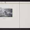
This broad, pointed angular slab is 3ft 6ins high, 4ft broad at the centre and 2ft 8ins broad at the base, and 1ft 4ins thick; it faces NE-SW. There is another pointed stone set firmly on end in the peat, 147ft to the NE; it protrudes 2ft from the ground.
Name Book 1873; RCAHMS 1911.
These two stones are as described above. The northern stone is
of no archaeological importance.
Resurveyed at 1:2500.
Visited by OS (E G C) 10 April 1961 and (R D) 17 November 1964.
The standing stone at ND 0488 5843 is as described above. The second stone, at ND 0491 5847, although not impressive, being 0.45m by 0.35m and 0.5m high, does appear to have been set up and cannot be completely dismissed. No other stones occur in the immediate vicinity, which is blanketed by peat.
Revised at 1:2500
Visited by OS (J B) 20 July 1981.

